You are here: Home > Network List > N4 - Central and EAstern US Network Stations List
> Station Q56A Snyder Ridge, Maysville, WV, USA > Earthquake Result Viewer
Q56A Snyder Ridge, Maysville, WV, USA - Earthquake Result Viewer
| Earthquake location: |
Near Coast Of Northern Chile |
| Earthquake latitude/longitude: |
-26.1/-70.6 |
| Earthquake time(UTC): |
2016/07/25 (207) 17:26:49 GMT |
| Earthquake Depth: |
68 km |
| Earthquake Magnitude: |
6.2 MB |
| Earthquake Catalog/Contributor: |
NEIC PDE/NEIC COMCAT |
|
| Network: |
N4 Central and EAstern US Network |
| Station: |
Q56A Snyder Ridge, Maysville, WV, USA |
| Lat/Lon: |
39.04 N/79.19 W |
| Elevation: |
430 m |
|
| Distance: |
65.3 deg |
| Az: |
352.686 deg |
| Baz: |
171.548 deg |
| Ray Param: |
0.05820013 |
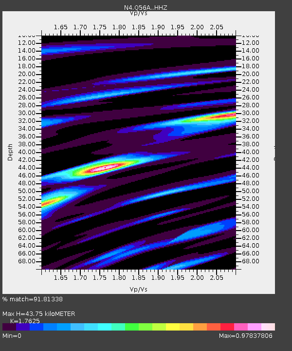
| Estimated Moho Depth: |
43.75 km |
| Estimated Crust Vp/Vs: |
1.76 |
| Assumed Crust Vp: |
6.159 km/s |
| Estimated Crust Vs: |
3.494 km/s |
| Estimated Crust Poisson's Ratio: |
0.26 |
|
| Radial Match: |
91.81338 % |
| Radial Bump: |
319 |
| Transverse Match: |
88.546074 % |
| Transverse Bump: |
400 |
| SOD ConfigId: |
11737051 |
| Insert Time: |
2019-04-25 04:22:01.048 +0000 |
| GWidth: |
2.5 |
| Max Bumps: |
400 |
| Tol: |
0.001 |
|

Signal To Noise
| Channel | StoN | STA | LTA |
| N4:Q56A: :HHZ:20160725T17:36:53.880017Z | 13.346107 | 8.6358403E-7 | 6.470682E-8 |
| N4:Q56A: :HHN:20160725T17:36:53.880017Z | 6.5082965 | 4.0761577E-7 | 6.263018E-8 |
| N4:Q56A: :HHE:20160725T17:36:53.880017Z | 2.3763695 | 1.5701416E-7 | 6.607312E-8 |
| Arrivals |
| Ps | 5.6 SECOND |
| PpPs | 19 SECOND |
| PsPs/PpSs | 25 SECOND |


