You are here: Home > Network List > N4 - Central and EAstern US Network Stations List
> Station R32B Long Quarter, Great Bend, KS, USA > Earthquake Result Viewer
R32B Long Quarter, Great Bend, KS, USA - Earthquake Result Viewer
| Earthquake location: |
Near Coast Of Northern Chile |
| Earthquake latitude/longitude: |
-26.1/-70.6 |
| Earthquake time(UTC): |
2016/07/25 (207) 17:26:49 GMT |
| Earthquake Depth: |
68 km |
| Earthquake Magnitude: |
6.2 MB |
| Earthquake Catalog/Contributor: |
NEIC PDE/NEIC COMCAT |
|
| Network: |
N4 Central and EAstern US Network |
| Station: |
R32B Long Quarter, Great Bend, KS, USA |
| Lat/Lon: |
38.42 N/98.71 W |
| Elevation: |
568 m |
|
| Distance: |
69.4 deg |
| Az: |
336.742 deg |
| Baz: |
153.127 deg |
| Ray Param: |
0.055536516 |
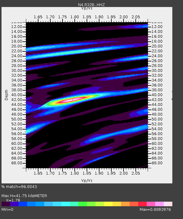
| Estimated Moho Depth: |
41.75 km |
| Estimated Crust Vp/Vs: |
1.79 |
| Assumed Crust Vp: |
6.483 km/s |
| Estimated Crust Vs: |
3.622 km/s |
| Estimated Crust Poisson's Ratio: |
0.27 |
|
| Radial Match: |
96.8043 % |
| Radial Bump: |
289 |
| Transverse Match: |
84.020164 % |
| Transverse Bump: |
400 |
| SOD ConfigId: |
11737051 |
| Insert Time: |
2019-04-25 04:22:02.973 +0000 |
| GWidth: |
2.5 |
| Max Bumps: |
400 |
| Tol: |
0.001 |
|

Signal To Noise
| Channel | StoN | STA | LTA |
| N4:R32B: :HHZ:20160725T17:37:19.729993Z | 26.51115 | 1.72121E-6 | 6.4924E-8 |
| N4:R32B: :HHN:20160725T17:37:19.729993Z | 10.402305 | 8.1766115E-7 | 7.860385E-8 |
| N4:R32B: :HHE:20160725T17:37:19.729993Z | 7.5206256 | 5.671502E-7 | 7.5412636E-8 |
| Arrivals |
| Ps | 5.3 SECOND |
| PpPs | 17 SECOND |
| PsPs/PpSs | 23 SECOND |


