You are here: Home > Network List > N4 - Central and EAstern US Network Stations List
> Station V55A Morning Dew, Taylorsville, NC, USA > Earthquake Result Viewer
V55A Morning Dew, Taylorsville, NC, USA - Earthquake Result Viewer
| Earthquake location: |
Near Coast Of Northern Chile |
| Earthquake latitude/longitude: |
-26.1/-70.6 |
| Earthquake time(UTC): |
2016/07/25 (207) 17:26:49 GMT |
| Earthquake Depth: |
68 km |
| Earthquake Magnitude: |
6.2 MB |
| Earthquake Catalog/Contributor: |
NEIC PDE/NEIC COMCAT |
|
| Network: |
N4 Central and EAstern US Network |
| Station: |
V55A Morning Dew, Taylorsville, NC, USA |
| Lat/Lon: |
35.85 N/81.21 W |
| Elevation: |
313 m |
|
| Distance: |
62.4 deg |
| Az: |
350.323 deg |
| Baz: |
169.278 deg |
| Ray Param: |
0.060062736 |
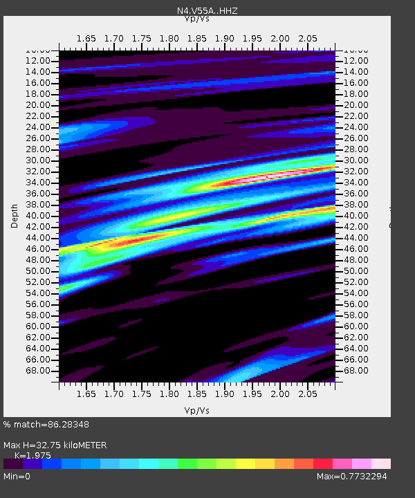
| Estimated Moho Depth: |
32.75 km |
| Estimated Crust Vp/Vs: |
1.98 |
| Assumed Crust Vp: |
6.419 km/s |
| Estimated Crust Vs: |
3.25 km/s |
| Estimated Crust Poisson's Ratio: |
0.33 |
|
| Radial Match: |
86.28348 % |
| Radial Bump: |
400 |
| Transverse Match: |
78.4954 % |
| Transverse Bump: |
400 |
| SOD ConfigId: |
11737051 |
| Insert Time: |
2019-04-25 04:22:25.321 +0000 |
| GWidth: |
2.5 |
| Max Bumps: |
400 |
| Tol: |
0.001 |
|

Signal To Noise
| Channel | StoN | STA | LTA |
| N4:V55A: :HHZ:20160725T17:36:35.120007Z | 8.138771 | 6.853134E-7 | 8.420354E-8 |
| N4:V55A: :HHN:20160725T17:36:35.120007Z | 2.599088 | 3.745586E-7 | 1.4411155E-7 |
| N4:V55A: :HHE:20160725T17:36:35.120007Z | 1.2299116 | 1.0612068E-7 | 8.628317E-8 |
| Arrivals |
| Ps | 5.2 SECOND |
| PpPs | 15 SECOND |
| PsPs/PpSs | 20 SECOND |


