You are here: Home > Network List > N4 - Central and EAstern US Network Stations List
> Station Y59A Loris, SC, USA > Earthquake Result Viewer
Y59A Loris, SC, USA - Earthquake Result Viewer
| Earthquake location: |
Near Coast Of Northern Chile |
| Earthquake latitude/longitude: |
-26.1/-70.6 |
| Earthquake time(UTC): |
2016/07/25 (207) 17:26:49 GMT |
| Earthquake Depth: |
68 km |
| Earthquake Magnitude: |
6.2 MB |
| Earthquake Catalog/Contributor: |
NEIC PDE/NEIC COMCAT |
|
| Network: |
N4 Central and EAstern US Network |
| Station: |
Y59A Loris, SC, USA |
| Lat/Lon: |
33.99 N/78.87 W |
| Elevation: |
2.0 m |
|
| Distance: |
60.3 deg |
| Az: |
352.131 deg |
| Baz: |
171.479 deg |
| Ray Param: |
0.061463356 |
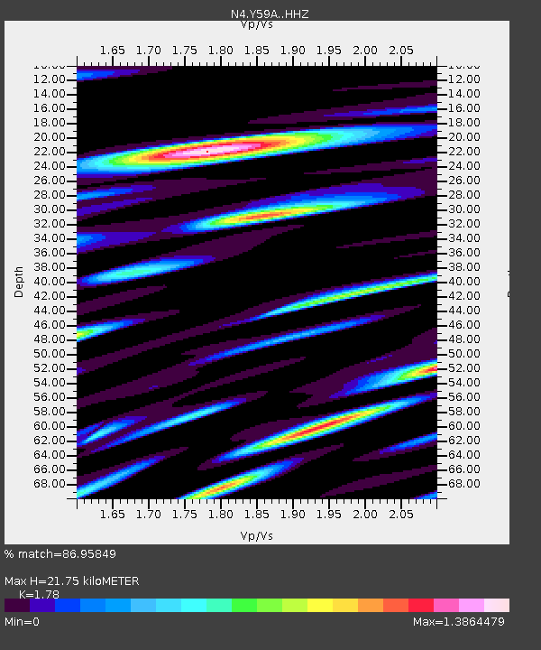
| Estimated Moho Depth: |
21.75 km |
| Estimated Crust Vp/Vs: |
1.78 |
| Assumed Crust Vp: |
6.24 km/s |
| Estimated Crust Vs: |
3.506 km/s |
| Estimated Crust Poisson's Ratio: |
0.27 |
|
| Radial Match: |
86.95849 % |
| Radial Bump: |
400 |
| Transverse Match: |
69.78949 % |
| Transverse Bump: |
400 |
| SOD ConfigId: |
11737051 |
| Insert Time: |
2019-04-25 04:22:36.626 +0000 |
| GWidth: |
2.5 |
| Max Bumps: |
400 |
| Tol: |
0.001 |
|

Signal To Noise
| Channel | StoN | STA | LTA |
| N4:Y59A: :HHZ:20160725T17:36:20.599988Z | 3.464862 | 7.409541E-7 | 2.1384807E-7 |
| N4:Y59A: :HHN:20160725T17:36:20.599988Z | 2.786993 | 9.041934E-7 | 3.2443333E-7 |
| N4:Y59A: :HHE:20160725T17:36:20.599988Z | 1.2093382 | 3.7568194E-7 | 3.1065085E-7 |
| Arrivals |
| Ps | 2.8 SECOND |
| PpPs | 9.3 SECOND |
| PsPs/PpSs | 12 SECOND |


