You are here: Home > Network List > GS - US Geological Survey Networks Stations List
> Station DEC07 Decatur Surface Seismic Site, Decatur, IL, USA > Earthquake Result Viewer
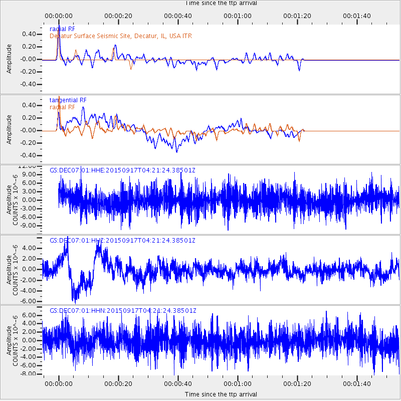
DEC07 Decatur Surface Seismic Site, Decatur, IL, USA - Earthquake Result Viewer
*The percent match for this event was below the threshold and hence no stack was calculated.
| Earthquake location: |
Near Coast Of Central Chile |
| Earthquake latitude/longitude: |
-31.5/-71.8 |
| Earthquake time(UTC): |
2015/09/17 (260) 04:10:31 GMT |
| Earthquake Depth: |
40 km |
| Earthquake Magnitude: |
6.3 MB |
| Earthquake Catalog/Contributor: |
NEIC PDE/NEIC COMCAT |
|
| Network: |
GS US Geological Survey Networks |
| Station: |
DEC07 Decatur Surface Seismic Site, Decatur, IL, USA |
| Lat/Lon: |
39.86 N/88.90 W |
| Elevation: |
212 m |
|
| Distance: |
72.8 deg |
| Az: |
346.273 deg |
| Baz: |
164.736 deg |
| Ray Param: |
$rayparam |
*The percent match for this event was below the threshold and hence was not used in the summary stack. |
|
| Radial Match: |
63.021374 % |
| Radial Bump: |
400 |
| Transverse Match: |
30.274399 % |
| Transverse Bump: |
400 |
| SOD ConfigId: |
1156111 |
| Insert Time: |
2015-10-01 04:32:11.237 +0000 |
| GWidth: |
2.5 |
| Max Bumps: |
400 |
| Tol: |
0.001 |
|
Signal To Noise
| Channel | StoN | STA | LTA |
| GS:DEC07:01:HHZ:20150917T04:21:24.38501Z | 3.1137192 | 2.6874961E-6 | 8.631145E-7 |
| GS:DEC07:01:HHN:20150917T04:21:24.38501Z | 1.1582336 | 2.811585E-6 | 2.4274766E-6 |
| GS:DEC07:01:HHE:20150917T04:21:24.38501Z | 0.9944298 | 3.464816E-6 | 3.4842235E-6 |
| Arrivals |
| Ps | |
| PpPs | |
| PsPs/PpSs | |


