You are here: Home > Network List > US - United States National Seismic Network Stations List
> Station NATX Nacogdoches, Texas, USA > Earthquake Result Viewer
NATX Nacogdoches, Texas, USA - Earthquake Result Viewer
| Earthquake location: |
Near Coast Of Northern Chile |
| Earthquake latitude/longitude: |
-22.9/-70.2 |
| Earthquake time(UTC): |
2007/11/15 (319) 15:05:58 GMT |
| Earthquake Depth: |
26 km |
| Earthquake Magnitude: |
6.1 MB, 6.6 MS, 6.8 MW, 6.6 MW |
| Earthquake Catalog/Contributor: |
WHDF/NEIC |
|
| Network: |
US United States National Seismic Network |
| Station: |
NATX Nacogdoches, Texas, USA |
| Lat/Lon: |
31.76 N/94.66 W |
| Elevation: |
156 m |
|
| Distance: |
59.2 deg |
| Az: |
335.789 deg |
| Baz: |
153.65 deg |
| Ray Param: |
0.062313568 |
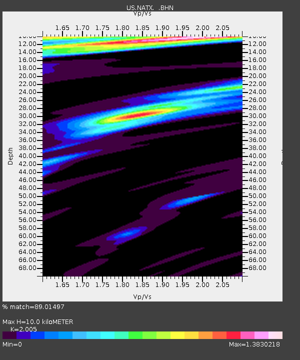
| Estimated Moho Depth: |
10.0 km |
| Estimated Crust Vp/Vs: |
2.01 |
| Assumed Crust Vp: |
5.738 km/s |
| Estimated Crust Vs: |
2.862 km/s |
| Estimated Crust Poisson's Ratio: |
0.33 |
|
| Radial Match: |
89.01497 % |
| Radial Bump: |
400 |
| Transverse Match: |
67.18923 % |
| Transverse Bump: |
400 |
| SOD ConfigId: |
2564 |
| Insert Time: |
2010-03-05 05:43:50.663 +0000 |
| GWidth: |
2.5 |
| Max Bumps: |
400 |
| Tol: |
0.001 |
|

Signal To Noise
| Channel | StoN | STA | LTA |
| US:NATX: :BHN:20071115T15:15:26.100Z | 1.2287686 | 6.750901E-7 | 5.4940375E-7 |
| US:NATX: :BHE:20071115T15:15:26.100Z | 1.5892657 | 7.4307695E-7 | 4.6755991E-7 |
| US:NATX: :BHZ:20071115T15:15:26.100Z | 4.2803755 | 1.4358316E-6 | 3.354452E-7 |
| Arrivals |
| Ps | 1.8 SECOND |
| PpPs | 5.1 SECOND |
| PsPs/PpSs | 6.9 SECOND |


