NATX Nacogdoches, Texas, USA - Earthquake Result Viewer
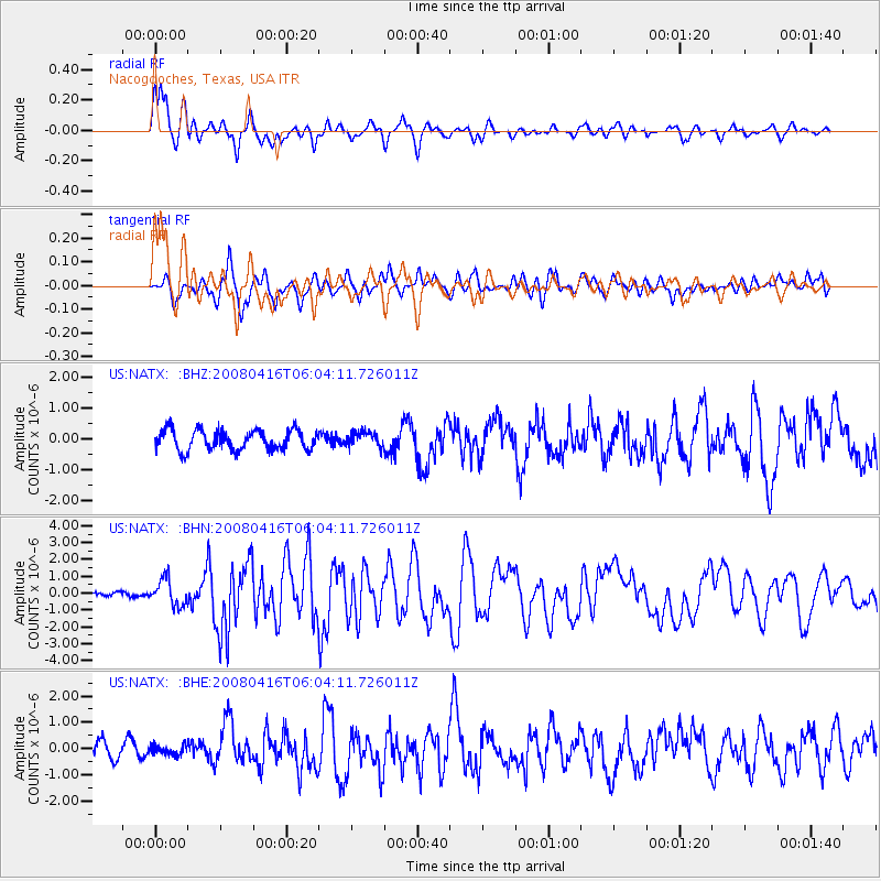
Earthquake location: Andreanof Islands, Aleutian Is.
Earthquake latitude/longitude: 51.9/-179.2
Earthquake time(UTC): 2008/04/16 (107) 05:54:19 GMT
Earthquake Depth: 13 km
Earthquake Magnitude: 6.1 MB, 6.5 MS, 6.6 MW, 6.6 MW
Earthquake Catalog/Contributor: WHDF/NEIC
Network: US United States National Seismic Network
Station: NATX Nacogdoches, Texas, USA
Lat/Lon: 31.76 N/94.66 W
Elevation: 156 m
Distance: 62.5 deg
Az: 72.91 deg
Baz: 315.926 deg
Ray Param: 0.060171798
Estimated Moho Depth: 31.0 km
Estimated Crust Vp/Vs: 1.82
Assumed Crust Vp: 5.738 km/s
Estimated Crust Vs: 3.162 km/s
Estimated Crust Poisson's Ratio: 0.28
Radial Match: 88.95983 %
Radial Bump: 400
Transverse Match: 76.99145 %
Transverse Bump: 400
SOD ConfigId: 2504
Insert Time: 2010-03-05 05:44:00.676 +0000
GWidth: 2.5
Max Bumps: 400
Tol: 0.001

Signal To Noise

ChannelStoNSTALTA
US:NATX: :BHN:20080416T06:04:11.726011Z3.8460967.752385E-72.0156503E-7
US:NATX: :BHE:20080416T06:04:11.726011Z0.60525631.8291527E-73.0221125E-7
US:NATX: :BHZ:20080416T06:04:11.726011Z0.743286972.4067413E-73.2379705E-7
Arrivals
Ps4.6 SECOND
PpPs15 SECOND
PsPs/PpSs19 SECOND