You are here: Home > Network List > US - United States National Seismic Network Stations List
> Station NATX Nacogdoches, Texas, USA > Earthquake Result Viewer
NATX Nacogdoches, Texas, USA - Earthquake Result Viewer
| Earthquake location: |
North Of Severnaya Zemlya |
| Earthquake latitude/longitude: |
84.9/99.4 |
| Earthquake time(UTC): |
2005/03/06 (065) 05:21:43 GMT |
| Earthquake Depth: |
10 km |
| Earthquake Magnitude: |
6.1 MB, 6.1 MS, 6.2 MW, 6.2 MW |
| Earthquake Catalog/Contributor: |
WHDF/NEIC |
|
| Network: |
US United States National Seismic Network |
| Station: |
NATX Nacogdoches, Texas, USA |
| Lat/Lon: |
31.76 N/94.66 W |
| Elevation: |
156 m |
|
| Distance: |
63.4 deg |
| Az: |
13.38 deg |
| Baz: |
358.62 deg |
| Ray Param: |
0.059631847 |
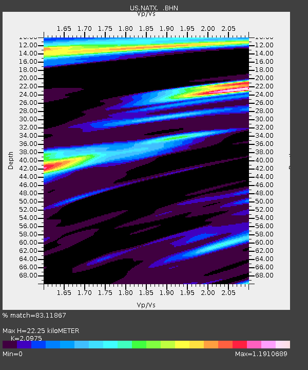
| Estimated Moho Depth: |
22.25 km |
| Estimated Crust Vp/Vs: |
2.10 |
| Assumed Crust Vp: |
5.738 km/s |
| Estimated Crust Vs: |
2.736 km/s |
| Estimated Crust Poisson's Ratio: |
0.35 |
|
| Radial Match: |
83.11867 % |
| Radial Bump: |
400 |
| Transverse Match: |
81.35497 % |
| Transverse Bump: |
400 |
| SOD ConfigId: |
110177 |
| Insert Time: |
2010-03-05 05:44:10.070 +0000 |
| GWidth: |
2.5 |
| Max Bumps: |
400 |
| Tol: |
0.001 |
|

Signal To Noise
| Channel | StoN | STA | LTA |
| US:NATX: :BHN:20050306T05:31:41.539009Z | 1.3756812 | 5.107614E-7 | 3.7127893E-7 |
| US:NATX: :BHE:20050306T05:31:41.539009Z | 1.1946821 | 9.4419335E-7 | 7.903302E-7 |
| US:NATX: :BHZ:20050306T05:31:41.539009Z | 2.7963223 | 2.544307E-6 | 9.098761E-7 |
| Arrivals |
| Ps | 4.4 SECOND |
| PpPs | 12 SECOND |
| PsPs/PpSs | 16 SECOND |


