You are here: Home > Network List > UW - Pacific Northwest Regional Seismic Network Stations List
> Station LEBA Lebam, WA, USA > Earthquake Result Viewer
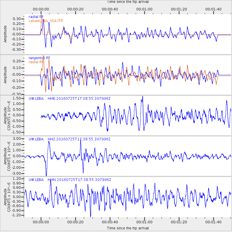
LEBA Lebam, WA, USA - Earthquake Result Viewer
*The percent match for this event was below the threshold and hence no stack was calculated.
| Earthquake location: |
Near Coast Of Northern Chile |
| Earthquake latitude/longitude: |
-26.1/-70.6 |
| Earthquake time(UTC): |
2016/07/25 (207) 17:26:49 GMT |
| Earthquake Depth: |
68 km |
| Earthquake Magnitude: |
6.2 MB |
| Earthquake Catalog/Contributor: |
NEIC PDE/NEIC COMCAT |
|
| Network: |
UW Pacific Northwest Regional Seismic Network |
| Station: |
LEBA Lebam, WA, USA |
| Lat/Lon: |
46.55 N/123.56 W |
| Elevation: |
73 m |
|
| Distance: |
86.7 deg |
| Az: |
326.528 deg |
| Baz: |
134.07 deg |
| Ray Param: |
$rayparam |
*The percent match for this event was below the threshold and hence was not used in the summary stack. |
|
| Radial Match: |
81.12015 % |
| Radial Bump: |
400 |
| Transverse Match: |
73.14278 % |
| Transverse Bump: |
400 |
| SOD ConfigId: |
11737051 |
| Insert Time: |
2019-04-25 04:26:37.239 +0000 |
| GWidth: |
2.5 |
| Max Bumps: |
400 |
| Tol: |
0.001 |
|
Signal To Noise
| Channel | StoN | STA | LTA |
| UW:LEBA: :HHZ:20160725T17:38:55.307996Z | 10.952472 | 1.4326183E-6 | 1.308032E-7 |
| UW:LEBA: :HHN:20160725T17:38:55.307996Z | 1.0534881 | 2.0905416E-7 | 1.9843998E-7 |
| UW:LEBA: :HHE:20160725T17:38:55.307996Z | 2.5366344 | 4.1339246E-7 | 1.6296887E-7 |
| Arrivals |
| Ps | |
| PpPs | |
| PsPs/PpSs | |


