You are here: Home > Network List > UW - Pacific Northwest Regional Seismic Network Stations List
> Station YACT Amboy, WA, USA > Earthquake Result Viewer
YACT Amboy, WA, USA - Earthquake Result Viewer

| Earthquake location: |
Near Coast Of Northern Chile |
| Earthquake latitude/longitude: |
-26.1/-70.6 |
| Earthquake time(UTC): |
2016/07/25 (207) 17:26:49 GMT |
| Earthquake Depth: |
68 km |
| Earthquake Magnitude: |
6.2 MB |
| Earthquake Catalog/Contributor: |
NEIC PDE/NEIC COMCAT |
|
| Network: |
UW Pacific Northwest Regional Seismic Network |
| Station: |
YACT Amboy, WA, USA |
| Lat/Lon: |
45.93 N/122.42 W |
| Elevation: |
211 m |
|
| Distance: |
85.7 deg |
| Az: |
326.647 deg |
| Baz: |
134.901 deg |
| Ray Param: |
0.04444144 |
| Estimated Moho Depth: |
10.0 km |
| Estimated Crust Vp/Vs: |
1.76 |
| Assumed Crust Vp: |
6.566 km/s |
| Estimated Crust Vs: |
3.725 km/s |
| Estimated Crust Poisson's Ratio: |
0.26 |
|
| Radial Match: |
83.34916 % |
| Radial Bump: |
400 |
| Transverse Match: |
86.59487 % |
| Transverse Bump: |
400 |
| SOD ConfigId: |
11737051 |
| Insert Time: |
2019-04-25 04:26:50.236 +0000 |
| GWidth: |
2.5 |
| Max Bumps: |
400 |
| Tol: |
0.001 |
|
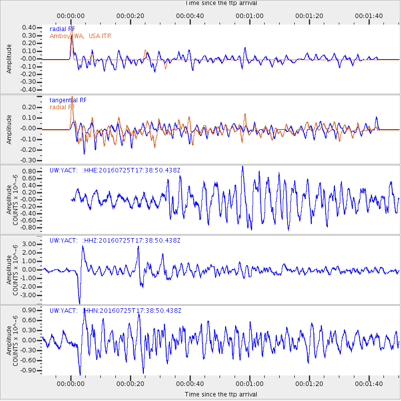
Signal To Noise
| Channel | StoN | STA | LTA |
| UW:YACT: :HHZ:20160725T17:38:50.438Z | 13.809174 | 1.5816197E-6 | 1.1453399E-7 |
| UW:YACT: :HHN:20160725T17:38:50.438Z | 4.6656375 | 4.568405E-7 | 9.7915986E-8 |
| UW:YACT: :HHE:20160725T17:38:50.438Z | 2.033015 | 2.6743842E-7 | 1.3154768E-7 |
| Arrivals |
| Ps | 1.2 SECOND |
| PpPs | 4.1 SECOND |
| PsPs/PpSs | 5.3 SECOND |


