You are here: Home > Network List > WU - The Southern Ontario Seismic Network Stations List
> Station PLIO Pelee Island, Stone Alvar Conservation Area, Ontario, Canad > Earthquake Result Viewer
PLIO Pelee Island, Stone Alvar Conservation Area, Ontario, Canad - Earthquake Result Viewer
| Earthquake location: |
Near Coast Of Northern Chile |
| Earthquake latitude/longitude: |
-26.1/-70.6 |
| Earthquake time(UTC): |
2016/07/25 (207) 17:26:49 GMT |
| Earthquake Depth: |
68 km |
| Earthquake Magnitude: |
6.2 MB |
| Earthquake Catalog/Contributor: |
NEIC PDE/NEIC COMCAT |
|
| Network: |
WU The Southern Ontario Seismic Network |
| Station: |
PLIO Pelee Island, Stone Alvar Conservation Area, Ontario, Canad |
| Lat/Lon: |
41.75 N/82.63 W |
| Elevation: |
143 m |
|
| Distance: |
68.4 deg |
| Az: |
350.383 deg |
| Baz: |
168.42 deg |
| Ray Param: |
0.056159057 |
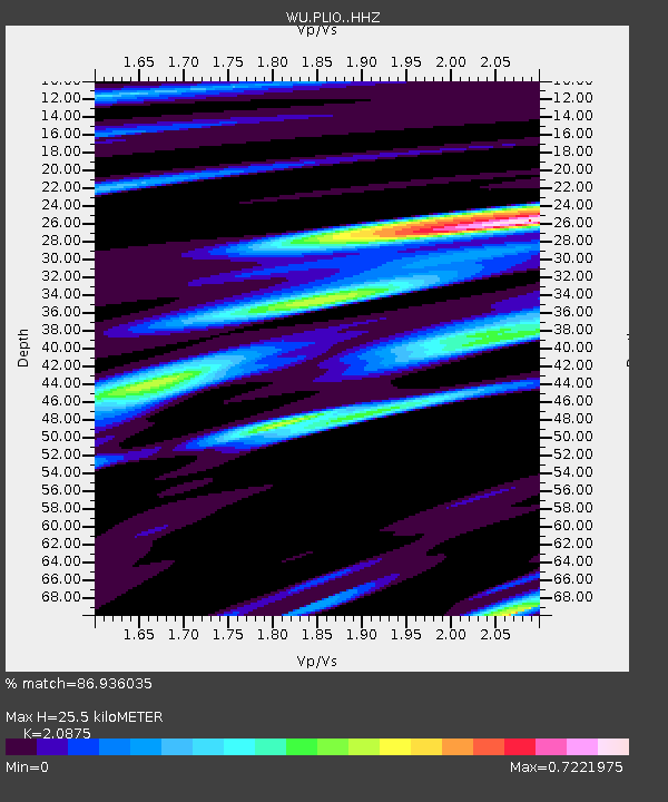
| Estimated Moho Depth: |
25.5 km |
| Estimated Crust Vp/Vs: |
2.09 |
| Assumed Crust Vp: |
6.498 km/s |
| Estimated Crust Vs: |
3.113 km/s |
| Estimated Crust Poisson's Ratio: |
0.35 |
|
| Radial Match: |
86.936035 % |
| Radial Bump: |
400 |
| Transverse Match: |
68.03185 % |
| Transverse Bump: |
400 |
| SOD ConfigId: |
11737051 |
| Insert Time: |
2019-04-25 04:27:05.346 +0000 |
| GWidth: |
2.5 |
| Max Bumps: |
400 |
| Tol: |
0.001 |
|

Signal To Noise
| Channel | StoN | STA | LTA |
| WU:PLIO: :HHZ:20160725T17:37:13.690015Z | 4.0917215 | 7.8509015E-7 | 1.9187283E-7 |
| WU:PLIO: :HHN:20160725T17:37:13.690015Z | 3.030472 | 3.6981876E-7 | 1.2203338E-7 |
| WU:PLIO: :HHE:20160725T17:37:13.690015Z | 1.4256855 | 1.479255E-7 | 1.0375746E-7 |
| Arrivals |
| Ps | 4.4 SECOND |
| PpPs | 12 SECOND |
| PsPs/PpSs | 16 SECOND |


