You are here: Home > Network List > US - United States National Seismic Network Stations List
> Station NATX Nacogdoches, Texas, USA > Earthquake Result Viewer
NATX Nacogdoches, Texas, USA - Earthquake Result Viewer
| Earthquake location: |
Samoa Islands Region |
| Earthquake latitude/longitude: |
-15.5/-172.1 |
| Earthquake time(UTC): |
2009/09/29 (272) 17:48:10 GMT |
| Earthquake Depth: |
18 km |
| Earthquake Magnitude: |
7.1 MB, 8.1 MS, 8.1 MW, 8.0 MW |
| Earthquake Catalog/Contributor: |
WHDF/NEIC |
|
| Network: |
US United States National Seismic Network |
| Station: |
NATX Nacogdoches, Texas, USA |
| Lat/Lon: |
31.76 N/94.66 W |
| Elevation: |
156 m |
|
| Distance: |
87.7 deg |
| Az: |
56.314 deg |
| Baz: |
250.354 deg |
| Ray Param: |
0.04310164 |
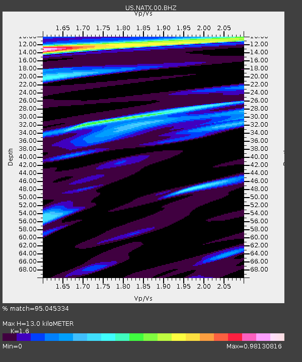
| Estimated Moho Depth: |
13.0 km |
| Estimated Crust Vp/Vs: |
1.60 |
| Assumed Crust Vp: |
5.738 km/s |
| Estimated Crust Vs: |
3.587 km/s |
| Estimated Crust Poisson's Ratio: |
0.18 |
|
| Radial Match: |
95.045334 % |
| Radial Bump: |
388 |
| Transverse Match: |
92.1781 % |
| Transverse Bump: |
400 |
| SOD ConfigId: |
2622 |
| Insert Time: |
2010-03-05 05:44:24.953 +0000 |
| GWidth: |
2.5 |
| Max Bumps: |
400 |
| Tol: |
0.001 |
|
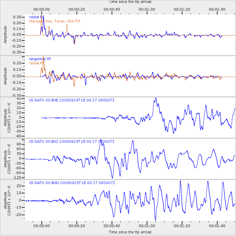
Signal To Noise
| Channel | StoN | STA | LTA |
| US:NATX:00:BHZ:20090929T18:00:27.060007Z | 17.676327 | 3.3289919E-6 | 1.8833053E-7 |
| US:NATX:00:BHN:20090929T18:00:27.060007Z | 1.1603786 | 2.9978045E-7 | 2.5834711E-7 |
| US:NATX:00:BHE:20090929T18:00:27.060007Z | 3.3795276 | 7.071818E-7 | 2.0925465E-7 |
| Arrivals |
| Ps | 1.4 SECOND |
| PpPs | 5.8 SECOND |
| PsPs/PpSs | 7.2 SECOND |


