You are here: Home > Network List > X614 - Homestake Gold Mine Three dimensional Broadband Array Stations List
> Station B4850 4850 level Homestake mine - near shaft 6 > Earthquake Result Viewer
B4850 4850 level Homestake mine - near shaft 6 - Earthquake Result Viewer
| Earthquake location: |
Near Coast Of Northern Chile |
| Earthquake latitude/longitude: |
-26.1/-70.6 |
| Earthquake time(UTC): |
2016/07/25 (207) 17:26:49 GMT |
| Earthquake Depth: |
68 km |
| Earthquake Magnitude: |
6.2 MB |
| Earthquake Catalog/Contributor: |
NEIC PDE/NEIC COMCAT |
|
| Network: |
X6 Homestake Gold Mine Three dimensional Broadband Array |
| Station: |
B4850 4850 level Homestake mine - near shaft 6 |
| Lat/Lon: |
44.35 N/103.76 W |
| Elevation: |
115 m |
|
| Distance: |
76.4 deg |
| Az: |
336.217 deg |
| Baz: |
149.643 deg |
| Ray Param: |
0.050890245 |
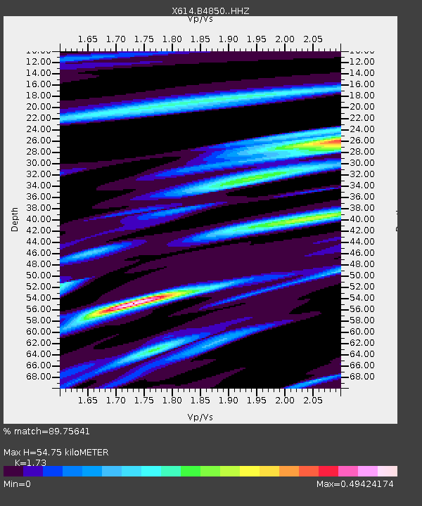
| Estimated Moho Depth: |
54.75 km |
| Estimated Crust Vp/Vs: |
1.73 |
| Assumed Crust Vp: |
6.242 km/s |
| Estimated Crust Vs: |
3.608 km/s |
| Estimated Crust Poisson's Ratio: |
0.25 |
|
| Radial Match: |
89.75641 % |
| Radial Bump: |
390 |
| Transverse Match: |
71.575584 % |
| Transverse Bump: |
400 |
| SOD ConfigId: |
11737051 |
| Insert Time: |
2019-04-25 04:27:18.492 +0000 |
| GWidth: |
2.5 |
| Max Bumps: |
400 |
| Tol: |
0.001 |
|

Signal To Noise
| Channel | StoN | STA | LTA |
| X6:B4850: :HHZ:20160725T17:38:01.050Z | 15.6366825 | 8.247203E-7 | 5.2742667E-8 |
| X6:B4850: :HHN:20160725T17:38:01.050Z | 10.743577 | 2.5283884E-7 | 2.3533955E-8 |
| X6:B4850: :HHE:20160725T17:38:01.050Z | 3.5706258 | 1.929826E-7 | 5.404728E-8 |
| Arrivals |
| Ps | 6.6 SECOND |
| PpPs | 23 SECOND |
| PsPs/PpSs | 30 SECOND |


