You are here: Home > Network List > US - United States National Seismic Network Stations List
> Station NATX Nacogdoches, Texas, USA > Earthquake Result Viewer
NATX Nacogdoches, Texas, USA - Earthquake Result Viewer

| Earthquake location: |
Tonga Islands |
| Earthquake latitude/longitude: |
-21.8/-175.1 |
| Earthquake time(UTC): |
2006/09/03 (246) 04:26:29 GMT |
| Earthquake Depth: |
37 km |
| Earthquake Magnitude: |
5.3 MB, 5.2 MS, 5.6 MW, 5.6 MW |
| Earthquake Catalog/Contributor: |
WHDF/NEIC |
|
| Network: |
US United States National Seismic Network |
| Station: |
NATX Nacogdoches, Texas, USA |
| Lat/Lon: |
31.76 N/94.66 W |
| Elevation: |
156 m |
|
| Distance: |
93.6 deg |
| Az: |
57.327 deg |
| Baz: |
246.686 deg |
| Ray Param: |
0.041218508 |
| Estimated Moho Depth: |
36.5 km |
| Estimated Crust Vp/Vs: |
2.03 |
| Assumed Crust Vp: |
5.738 km/s |
| Estimated Crust Vs: |
2.823 km/s |
| Estimated Crust Poisson's Ratio: |
0.34 |
|
| Radial Match: |
99.39967 % |
| Radial Bump: |
48 |
| Transverse Match: |
99.45602 % |
| Transverse Bump: |
35 |
| SOD ConfigId: |
2665 |
| Insert Time: |
2010-03-05 05:44:31.923 +0000 |
| GWidth: |
2.5 |
| Max Bumps: |
400 |
| Tol: |
0.001 |
|
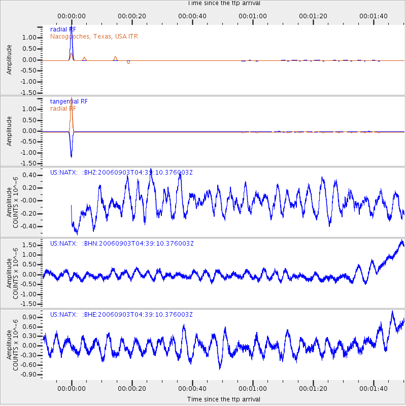
Signal To Noise
| Channel | StoN | STA | LTA |
| US:NATX: :BHN:20060903T04:39:10.376003Z | 0.40941322 | 1.2968808E-7 | 3.1676572E-7 |
| US:NATX: :BHE:20060903T04:39:10.376003Z | 0.6768748 | 1.658531E-7 | 2.4502773E-7 |
| US:NATX: :BHZ:20060903T04:39:10.376003Z | 0.7978452 | 1.5778868E-7 | 1.9776854E-7 |
| Arrivals |
| Ps | 6.7 SECOND |
| PpPs | 19 SECOND |
| PsPs/PpSs | 26 SECOND |


