You are here: Home > Network List > XD14 - Illuminating the architecture of the greater Mount St. Helens magmatic systems f Stations List
> Station MH03 "Mount St Helens, WA" > Earthquake Result Viewer
MH03 "Mount St Helens, WA" - Earthquake Result Viewer
| Earthquake location: |
Near Coast Of Northern Chile |
| Earthquake latitude/longitude: |
-26.1/-70.6 |
| Earthquake time(UTC): |
2016/07/25 (207) 17:26:49 GMT |
| Earthquake Depth: |
68 km |
| Earthquake Magnitude: |
6.2 MB |
| Earthquake Catalog/Contributor: |
NEIC PDE/NEIC COMCAT |
|
| Network: |
XD Illuminating the architecture of the greater Mount St. Helens magmatic systems f |
| Station: |
MH03 "Mount St Helens, WA" |
| Lat/Lon: |
46.27 N/122.59 W |
| Elevation: |
373 m |
|
| Distance: |
86.0 deg |
| Az: |
326.8 deg |
| Baz: |
134.787 deg |
| Ray Param: |
0.044212908 |
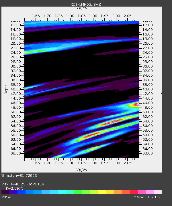
| Estimated Moho Depth: |
46.25 km |
| Estimated Crust Vp/Vs: |
2.10 |
| Assumed Crust Vp: |
6.566 km/s |
| Estimated Crust Vs: |
3.13 km/s |
| Estimated Crust Poisson's Ratio: |
0.35 |
|
| Radial Match: |
81.72923 % |
| Radial Bump: |
400 |
| Transverse Match: |
66.231804 % |
| Transverse Bump: |
400 |
| SOD ConfigId: |
11737051 |
| Insert Time: |
2019-04-25 04:27:37.682 +0000 |
| GWidth: |
2.5 |
| Max Bumps: |
400 |
| Tol: |
0.001 |
|

Signal To Noise
| Channel | StoN | STA | LTA |
| XD:MH03: :BHZ:20160725T17:38:52.024976Z | 15.306632 | 1.476642E-6 | 9.647073E-8 |
| XD:MH03: :BHN:20160725T17:38:52.024976Z | 4.878107 | 4.0942902E-7 | 8.393195E-8 |
| XD:MH03: :BHE:20160725T17:38:52.024976Z | 2.8558192 | 2.1949063E-7 | 7.6857326E-8 |
| Arrivals |
| Ps | 7.9 SECOND |
| PpPs | 21 SECOND |
| PsPs/PpSs | 29 SECOND |


