You are here: Home > Network List > XD14 - Illuminating the architecture of the greater Mount St. Helens magmatic systems f Stations List
> Station MN07 "Mount St Helens, WA" > Earthquake Result Viewer
MN07 "Mount St Helens, WA" - Earthquake Result Viewer
| Earthquake location: |
Near Coast Of Northern Chile |
| Earthquake latitude/longitude: |
-26.1/-70.6 |
| Earthquake time(UTC): |
2016/07/25 (207) 17:26:49 GMT |
| Earthquake Depth: |
68 km |
| Earthquake Magnitude: |
6.2 MB |
| Earthquake Catalog/Contributor: |
NEIC PDE/NEIC COMCAT |
|
| Network: |
XD Illuminating the architecture of the greater Mount St. Helens magmatic systems f |
| Station: |
MN07 "Mount St Helens, WA" |
| Lat/Lon: |
45.99 N/122.08 W |
| Elevation: |
861 m |
|
| Distance: |
85.6 deg |
| Az: |
326.856 deg |
| Baz: |
135.159 deg |
| Ray Param: |
0.0445294 |
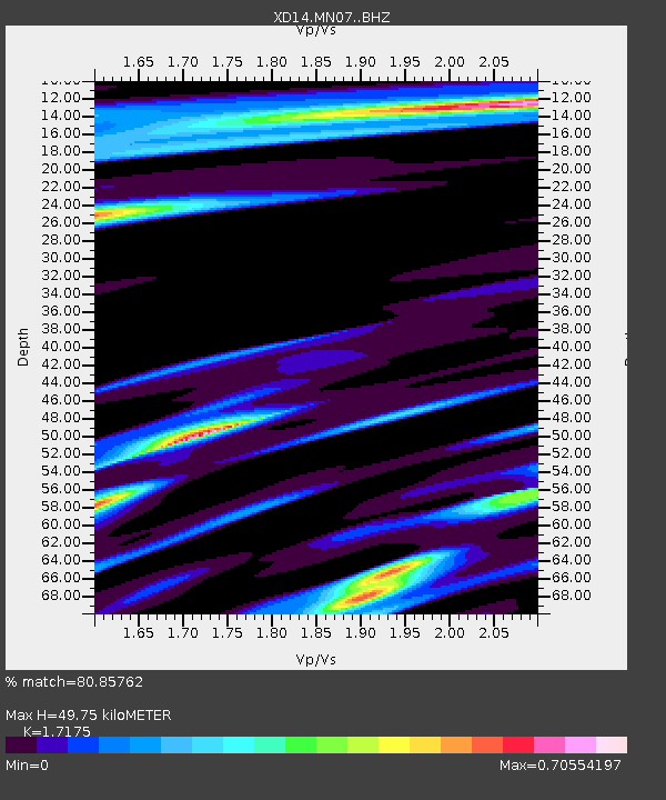
| Estimated Moho Depth: |
49.75 km |
| Estimated Crust Vp/Vs: |
1.72 |
| Assumed Crust Vp: |
6.566 km/s |
| Estimated Crust Vs: |
3.823 km/s |
| Estimated Crust Poisson's Ratio: |
0.24 |
|
| Radial Match: |
80.85762 % |
| Radial Bump: |
400 |
| Transverse Match: |
62.725414 % |
| Transverse Bump: |
400 |
| SOD ConfigId: |
11737051 |
| Insert Time: |
2019-04-25 04:28:01.381 +0000 |
| GWidth: |
2.5 |
| Max Bumps: |
400 |
| Tol: |
0.001 |
|

Signal To Noise
| Channel | StoN | STA | LTA |
| XD:MN07: :BHZ:20160725T17:38:49.830029Z | 26.265806 | 2.1574272E-6 | 8.213824E-8 |
| XD:MN07: :BHN:20160725T17:38:49.830029Z | 3.6969385 | 4.538158E-7 | 1.2275449E-7 |
| XD:MN07: :BHE:20160725T17:38:49.830029Z | 3.5555577 | 4.4060477E-7 | 1.2392002E-7 |
| Arrivals |
| Ps | 5.6 SECOND |
| PpPs | 20 SECOND |
| PsPs/PpSs | 26 SECOND |


