You are here: Home > Network List > XD14 - Illuminating the architecture of the greater Mount St. Helens magmatic systems f Stations List
> Station MQ07 "Mount St Helens, WA" > Earthquake Result Viewer
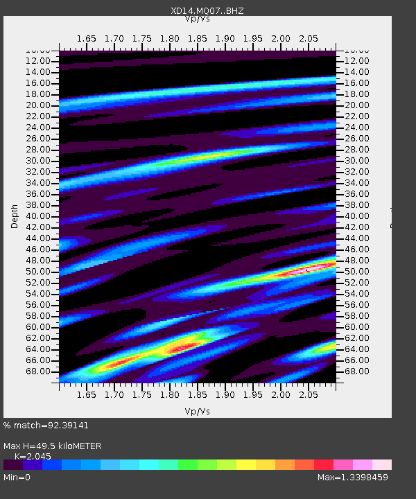
MQ07 "Mount St Helens, WA" - Earthquake Result Viewer
| Earthquake location: |
Near Coast Of Northern Chile |
| Earthquake latitude/longitude: |
-26.1/-70.6 |
| Earthquake time(UTC): |
2016/07/25 (207) 17:26:49 GMT |
| Earthquake Depth: |
68 km |
| Earthquake Magnitude: |
6.2 MB |
| Earthquake Catalog/Contributor: |
NEIC PDE/NEIC COMCAT |
|
| Network: |
XD Illuminating the architecture of the greater Mount St. Helens magmatic systems f |
| Station: |
MQ07 "Mount St Helens, WA" |
| Lat/Lon: |
45.81 N/122.11 W |
| Elevation: |
1037 m |
|
| Distance: |
85.5 deg |
| Az: |
326.713 deg |
| Baz: |
135.13 deg |
| Ray Param: |
0.04461385 |
| Estimated Moho Depth: |
49.5 km |
| Estimated Crust Vp/Vs: |
2.05 |
| Assumed Crust Vp: |
6.566 km/s |
| Estimated Crust Vs: |
3.211 km/s |
| Estimated Crust Poisson's Ratio: |
0.34 |
|
| Radial Match: |
92.39141 % |
| Radial Bump: |
400 |
| Transverse Match: |
78.341034 % |
| Transverse Bump: |
400 |
| SOD ConfigId: |
11737051 |
| Insert Time: |
2019-04-25 04:28:07.303 +0000 |
| GWidth: |
2.5 |
| Max Bumps: |
400 |
| Tol: |
0.001 |
|

Signal To Noise
| Channel | StoN | STA | LTA |
| XD:MQ07: :BHZ:20160725T17:38:49.234998Z | 20.021996 | 1.6641711E-6 | 8.311714E-8 |
| XD:MQ07: :BHN:20160725T17:38:49.234998Z | 9.43944 | 6.284598E-7 | 6.657808E-8 |
| XD:MQ07: :BHE:20160725T17:38:49.234998Z | 2.2113724 | 2.4212395E-7 | 1.0949036E-7 |
| Arrivals |
| Ps | 8.0 SECOND |
| PpPs | 22 SECOND |
| PsPs/PpSs | 31 SECOND |


