You are here: Home > Network List > US - United States National Seismic Network Stations List
> Station NATX Nacogdoches, Texas, USA > Earthquake Result Viewer
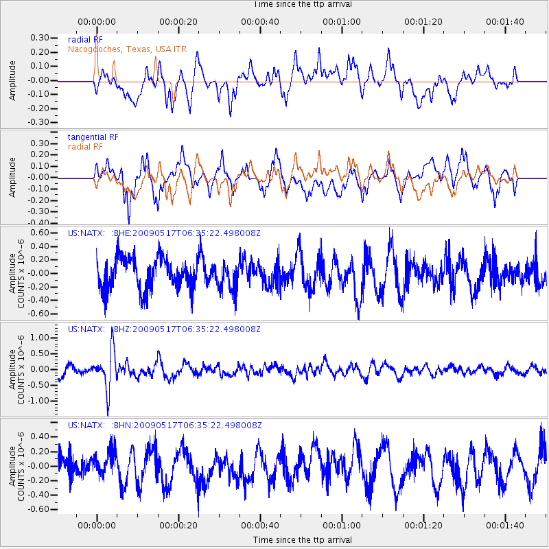
NATX Nacogdoches, Texas, USA - Earthquake Result Viewer
*The percent match for this event was below the threshold and hence no stack was calculated.
| Earthquake location: |
Tonga Islands |
| Earthquake latitude/longitude: |
-16.8/-173.5 |
| Earthquake time(UTC): |
2009/05/17 (137) 06:23:03 GMT |
| Earthquake Depth: |
67 km |
| Earthquake Magnitude: |
5.5 MB, 5.6 MW, 5.6 MW |
| Earthquake Catalog/Contributor: |
WHDF/NEIC |
|
| Network: |
US United States National Seismic Network |
| Station: |
NATX Nacogdoches, Texas, USA |
| Lat/Lon: |
31.76 N/94.66 W |
| Elevation: |
156 m |
|
| Distance: |
89.6 deg |
| Az: |
56.691 deg |
| Baz: |
249.986 deg |
| Ray Param: |
$rayparam |
*The percent match for this event was below the threshold and hence was not used in the summary stack. |
|
| Radial Match: |
55.02965 % |
| Radial Bump: |
400 |
| Transverse Match: |
58.20576 % |
| Transverse Bump: |
400 |
| SOD ConfigId: |
2760 |
| Insert Time: |
2010-03-05 05:44:41.924 +0000 |
| GWidth: |
2.5 |
| Max Bumps: |
400 |
| Tol: |
0.001 |
|
Signal To Noise
| Channel | StoN | STA | LTA |
| US:NATX: :BHZ:20090517T06:35:22.498008Z | 4.375953 | 6.1567454E-7 | 1.4069497E-7 |
| US:NATX: :BHN:20090517T06:35:22.498008Z | 0.93515277 | 1.8231532E-7 | 1.9495778E-7 |
| US:NATX: :BHE:20090517T06:35:22.498008Z | 0.8764315 | 2.0360454E-7 | 2.3231082E-7 |
| Arrivals |
| Ps | |
| PpPs | |
| PsPs/PpSs | |


