You are here: Home > Network List > US - United States National Seismic Network Stations List
> Station NATX Nacogdoches, Texas, USA > Earthquake Result Viewer
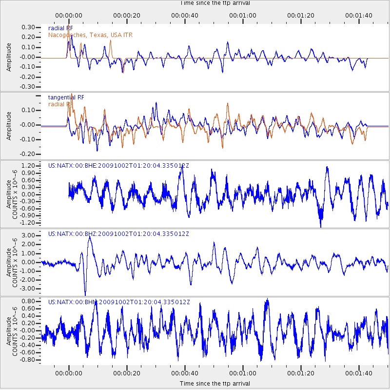
NATX Nacogdoches, Texas, USA - Earthquake Result Viewer
*The percent match for this event was below the threshold and hence no stack was calculated.
| Earthquake location: |
Tonga Islands |
| Earthquake latitude/longitude: |
-16.3/-173.5 |
| Earthquake time(UTC): |
2009/10/02 (275) 01:07:39 GMT |
| Earthquake Depth: |
8.0 km |
| Earthquake Magnitude: |
6.1 MB, 6.0 MS, 6.1 MW, 6.1 MW |
| Earthquake Catalog/Contributor: |
WHDF/NEIC |
|
| Network: |
US United States National Seismic Network |
| Station: |
NATX Nacogdoches, Texas, USA |
| Lat/Lon: |
31.76 N/94.66 W |
| Elevation: |
156 m |
|
| Distance: |
89.3 deg |
| Az: |
56.69 deg |
| Baz: |
250.383 deg |
| Ray Param: |
$rayparam |
*The percent match for this event was below the threshold and hence was not used in the summary stack. |
|
| Radial Match: |
67.1733 % |
| Radial Bump: |
400 |
| Transverse Match: |
70.29952 % |
| Transverse Bump: |
400 |
| SOD ConfigId: |
2622 |
| Insert Time: |
2010-03-05 05:44:57.101 +0000 |
| GWidth: |
2.5 |
| Max Bumps: |
400 |
| Tol: |
0.001 |
|
Signal To Noise
| Channel | StoN | STA | LTA |
| US:NATX:00:BHZ:20091002T01:20:04.335012Z | 3.781837 | 5.223876E-7 | 1.3813066E-7 |
| US:NATX:00:BHN:20091002T01:20:04.335012Z | 0.90930766 | 1.9056822E-7 | 2.0957506E-7 |
| US:NATX:00:BHE:20091002T01:20:04.335012Z | 0.7882562 | 2.5354873E-7 | 3.2165775E-7 |
| Arrivals |
| Ps | |
| PpPs | |
| PsPs/PpSs | |


