You are here: Home > Network List > II - Global Seismograph Network (GSN - IRIS/IDA) Stations List
> Station PFO Pinon Flat, California, USA > Earthquake Result Viewer
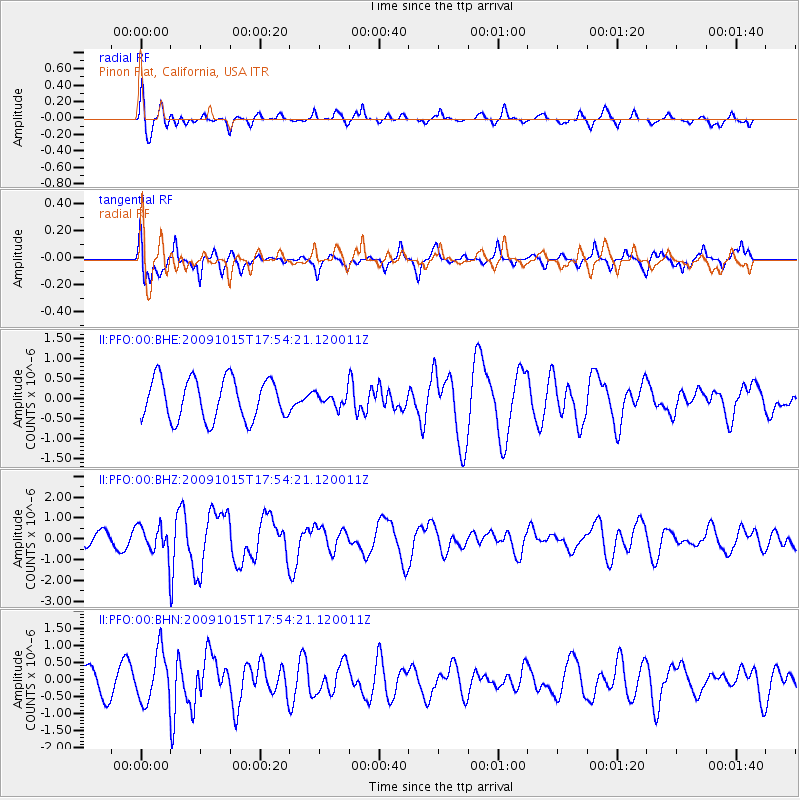
PFO Pinon Flat, California, USA - Earthquake Result Viewer
*The percent match for this event was below the threshold and hence no stack was calculated.
| Earthquake location: |
Galapagos Triple Junction Region |
| Earthquake latitude/longitude: |
3.3/-103.8 |
| Earthquake time(UTC): |
2009/10/15 (288) 17:48:21 GMT |
| Earthquake Depth: |
10 km |
| Earthquake Magnitude: |
5.9 MB, 5.7 MS, 6.0 MW, 6.0 MW |
| Earthquake Catalog/Contributor: |
WHDF/NEIC |
|
| Network: |
II Global Seismograph Network (GSN - IRIS/IDA) |
| Station: |
PFO Pinon Flat, California, USA |
| Lat/Lon: |
33.61 N/116.46 W |
| Elevation: |
1280 m |
|
| Distance: |
32.4 deg |
| Az: |
340.091 deg |
| Baz: |
155.958 deg |
| Ray Param: |
$rayparam |
*The percent match for this event was below the threshold and hence was not used in the summary stack. |
|
| Radial Match: |
60.522953 % |
| Radial Bump: |
400 |
| Transverse Match: |
72.875435 % |
| Transverse Bump: |
370 |
| SOD ConfigId: |
1 |
| Insert Time: |
2010-02-19 00:47:56.363 +0000 |
| GWidth: |
2.5 |
| Max Bumps: |
400 |
| Tol: |
0.001 |
|
Signal To Noise
| Channel | StoN | STA | LTA |
| II:PFO:00:BHZ:20091015T17:54:21.120011Z | 2.705506 | 7.255078E-7 | 2.6815974E-7 |
| II:PFO:00:BHN:20091015T17:54:21.120011Z | 1.7575834 | 7.396142E-7 | 4.2081317E-7 |
| II:PFO:00:BHE:20091015T17:54:21.120011Z | 0.3168158 | 1.6066022E-7 | 5.071093E-7 |
| Arrivals |
| Ps | |
| PpPs | |
| PsPs/PpSs | |


