You are here: Home > Network List > CI - Caltech Regional Seismic Network Stations List
> Station MLAC Mammoth Lakes, California, USA > Earthquake Result Viewer
MLAC Mammoth Lakes, California, USA - Earthquake Result Viewer
| Earthquake location: |
Near Coast Of Peru |
| Earthquake latitude/longitude: |
-13.5/-76.7 |
| Earthquake time(UTC): |
2006/10/20 (293) 10:48:56 GMT |
| Earthquake Depth: |
23 km |
| Earthquake Magnitude: |
5.9 MB, 6.6 MS, 6.7 MW, 6.6 MW |
| Earthquake Catalog/Contributor: |
WHDF/NEIC |
|
| Network: |
CI Caltech Regional Seismic Network |
| Station: |
MLAC Mammoth Lakes, California, USA |
| Lat/Lon: |
37.63 N/118.84 W |
| Elevation: |
2134 m |
|
| Distance: |
64.4 deg |
| Az: |
323.781 deg |
| Baz: |
133.61 deg |
| Ray Param: |
0.05891436 |
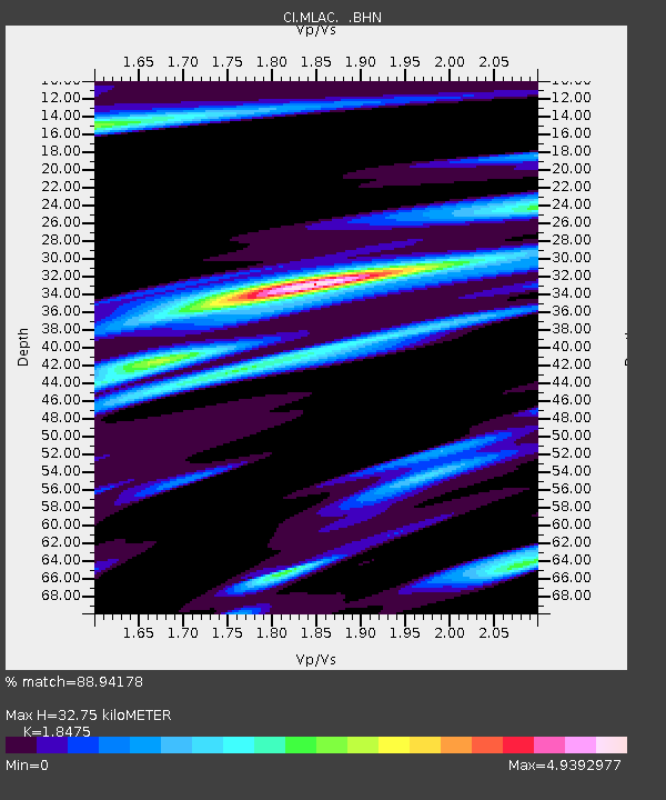
| Estimated Moho Depth: |
32.75 km |
| Estimated Crust Vp/Vs: |
1.85 |
| Assumed Crust Vp: |
6.291 km/s |
| Estimated Crust Vs: |
3.405 km/s |
| Estimated Crust Poisson's Ratio: |
0.29 |
|
| Radial Match: |
88.94178 % |
| Radial Bump: |
400 |
| Transverse Match: |
79.63312 % |
| Transverse Bump: |
400 |
| SOD ConfigId: |
2665 |
| Insert Time: |
2010-02-26 00:37:32.447 +0000 |
| GWidth: |
2.5 |
| Max Bumps: |
400 |
| Tol: |
0.001 |
|

Signal To Noise
| Channel | StoN | STA | LTA |
| CI:MLAC: :BHN:20061020T10:58:59.140005Z | 2.039933 | 4.975025E-7 | 2.438818E-7 |
| CI:MLAC: :BHE:20061020T10:58:59.140005Z | 1.116863 | 3.620057E-7 | 3.241272E-7 |
| CI:MLAC: :BHZ:20061020T10:58:59.140005Z | 4.8914876 | 7.522017E-7 | 1.5377769E-7 |
| Arrivals |
| Ps | 4.6 SECOND |
| PpPs | 14 SECOND |
| PsPs/PpSs | 19 SECOND |


