You are here: Home > Network List > PS - Pacific21 Stations List
> Station PSI Parapat, Indonesia > Earthquake Result Viewer
PSI Parapat, Indonesia - Earthquake Result Viewer
| Earthquake location: |
Admiralty Islands Region, P.N.G. |
| Earthquake latitude/longitude: |
-2.9/148.0 |
| Earthquake time(UTC): |
2016/07/25 (207) 19:38:44 GMT |
| Earthquake Depth: |
6.5 km |
| Earthquake Magnitude: |
6.3 MO |
| Earthquake Catalog/Contributor: |
NEIC PDE/NEIC ALERT |
|
| Network: |
PS Pacific21 |
| Station: |
PSI Parapat, Indonesia |
| Lat/Lon: |
2.69 N/98.92 E |
| Elevation: |
987 m |
|
| Distance: |
49.4 deg |
| Az: |
276.054 deg |
| Baz: |
96.167 deg |
| Ray Param: |
0.068762496 |
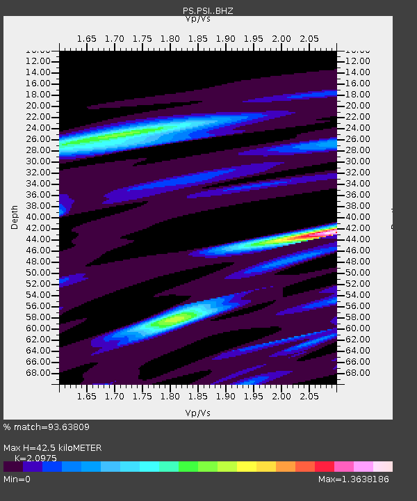
| Estimated Moho Depth: |
42.5 km |
| Estimated Crust Vp/Vs: |
2.10 |
| Assumed Crust Vp: |
6.468 km/s |
| Estimated Crust Vs: |
3.084 km/s |
| Estimated Crust Poisson's Ratio: |
0.35 |
|
| Radial Match: |
93.63809 % |
| Radial Bump: |
273 |
| Transverse Match: |
81.02064 % |
| Transverse Bump: |
400 |
| SOD ConfigId: |
11737051 |
| Insert Time: |
2019-04-25 04:34:07.461 +0000 |
| GWidth: |
2.5 |
| Max Bumps: |
400 |
| Tol: |
0.001 |
|
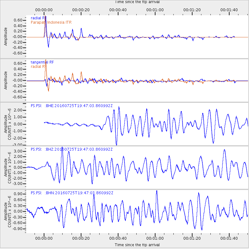
Signal To Noise
| Channel | StoN | STA | LTA |
| PS:PSI: :BHZ:20160725T19:47:03.860992Z | 7.080988 | 7.199778E-7 | 1.01677585E-7 |
| PS:PSI: :BHN:20160725T19:47:03.860992Z | 1.4836658 | 1.9754233E-7 | 1.3314477E-7 |
| PS:PSI: :BHE:20160725T19:47:03.860992Z | 3.1021783 | 4.4410805E-7 | 1.4316007E-7 |
| Arrivals |
| Ps | 7.6 SECOND |
| PpPs | 19 SECOND |
| PsPs/PpSs | 27 SECOND |


