You are here: Home > Network List > US - United States National Seismic Network Stations List
> Station NATX Nacogdoches, Texas, USA > Earthquake Result Viewer
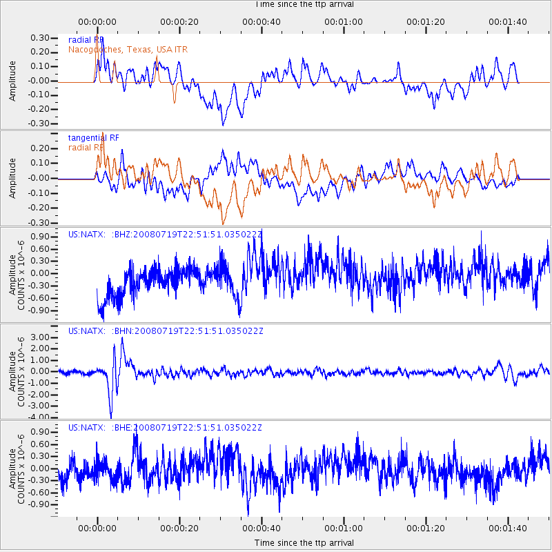
NATX Nacogdoches, Texas, USA - Earthquake Result Viewer
*The percent match for this event was below the threshold and hence no stack was calculated.
| Earthquake location: |
Fiji Islands Region |
| Earthquake latitude/longitude: |
-17.3/-177.3 |
| Earthquake time(UTC): |
2008/07/19 (201) 22:39:52 GMT |
| Earthquake Depth: |
391 km |
| Earthquake Magnitude: |
5.9 MB, 6.4 MW, 6.4 MW |
| Earthquake Catalog/Contributor: |
WHDF/NEIC |
|
| Network: |
US United States National Seismic Network |
| Station: |
NATX Nacogdoches, Texas, USA |
| Lat/Lon: |
31.76 N/94.66 W |
| Elevation: |
156 m |
|
| Distance: |
92.9 deg |
| Az: |
57.773 deg |
| Baz: |
251.537 deg |
| Ray Param: |
$rayparam |
*The percent match for this event was below the threshold and hence was not used in the summary stack. |
|
| Radial Match: |
56.570076 % |
| Radial Bump: |
400 |
| Transverse Match: |
51.022057 % |
| Transverse Bump: |
400 |
| SOD ConfigId: |
2504 |
| Insert Time: |
2010-03-05 05:45:31.918 +0000 |
| GWidth: |
2.5 |
| Max Bumps: |
400 |
| Tol: |
0.001 |
|
Signal To Noise
| Channel | StoN | STA | LTA |
| US:NATX: :BHN:20080719T22:51:51.035022Z | 11.02401 | 1.4939336E-6 | 1.3551636E-7 |
| US:NATX: :BHE:20080719T22:51:51.035022Z | 0.8625342 | 2.5002834E-7 | 2.8987643E-7 |
| US:NATX: :BHZ:20080719T22:51:51.035022Z | 1.1766722 | 3.980203E-7 | 3.382593E-7 |
| Arrivals |
| Ps | |
| PpPs | |
| PsPs/PpSs | |


