You are here: Home > Network List > TA - USArray Transportable Network (new EarthScope stations) Stations List
> Station C27K Jago River, AK, USA > Earthquake Result Viewer
C27K Jago River, AK, USA - Earthquake Result Viewer
| Earthquake location: |
Admiralty Islands Region, P.N.G. |
| Earthquake latitude/longitude: |
-2.9/148.0 |
| Earthquake time(UTC): |
2016/07/25 (207) 19:38:44 GMT |
| Earthquake Depth: |
6.5 km |
| Earthquake Magnitude: |
6.3 MO |
| Earthquake Catalog/Contributor: |
NEIC PDE/NEIC ALERT |
|
| Network: |
TA USArray Transportable Network (new EarthScope stations) |
| Station: |
C27K Jago River, AK, USA |
| Lat/Lon: |
69.63 N/143.71 W |
| Elevation: |
392 m |
|
| Distance: |
85.3 deg |
| Az: |
19.056 deg |
| Baz: |
248.604 deg |
| Ray Param: |
0.0448507 |
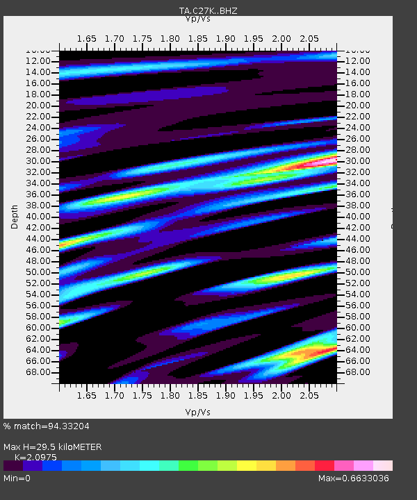
| Estimated Moho Depth: |
29.5 km |
| Estimated Crust Vp/Vs: |
2.10 |
| Assumed Crust Vp: |
6.522 km/s |
| Estimated Crust Vs: |
3.109 km/s |
| Estimated Crust Poisson's Ratio: |
0.35 |
|
| Radial Match: |
94.33204 % |
| Radial Bump: |
400 |
| Transverse Match: |
93.84231 % |
| Transverse Bump: |
373 |
| SOD ConfigId: |
11737051 |
| Insert Time: |
2019-04-25 04:34:27.561 +0000 |
| GWidth: |
2.5 |
| Max Bumps: |
400 |
| Tol: |
0.001 |
|

Signal To Noise
| Channel | StoN | STA | LTA |
| TA:C27K: :BHZ:20160725T19:50:50.549988Z | 3.964421 | 2.3495926E-7 | 5.9266977E-8 |
| TA:C27K: :BHN:20160725T19:50:50.549988Z | 0.9124091 | 6.04841E-8 | 6.6290546E-8 |
| TA:C27K: :BHE:20160725T19:50:50.549988Z | 1.197971 | 5.9486833E-8 | 4.965632E-8 |
| Arrivals |
| Ps | 5.1 SECOND |
| PpPs | 14 SECOND |
| PsPs/PpSs | 19 SECOND |


