You are here: Home > Network List > TA - USArray Transportable Network (new EarthScope stations) Stations List
> Station C24K Franklin Bluffs, AK, USA > Earthquake Result Viewer
C24K Franklin Bluffs, AK, USA - Earthquake Result Viewer
| Earthquake location: |
Admiralty Islands Region, P.N.G. |
| Earthquake latitude/longitude: |
-2.9/148.0 |
| Earthquake time(UTC): |
2016/07/25 (207) 19:38:44 GMT |
| Earthquake Depth: |
6.5 km |
| Earthquake Magnitude: |
6.3 MO |
| Earthquake Catalog/Contributor: |
NEIC PDE/NEIC ALERT |
|
| Network: |
TA USArray Transportable Network (new EarthScope stations) |
| Station: |
C24K Franklin Bluffs, AK, USA |
| Lat/Lon: |
69.72 N/148.70 W |
| Elevation: |
115 m |
|
| Distance: |
83.8 deg |
| Az: |
18.264 deg |
| Baz: |
243.853 deg |
| Ray Param: |
0.045958582 |
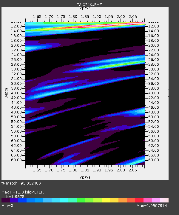
| Estimated Moho Depth: |
11.0 km |
| Estimated Crust Vp/Vs: |
1.99 |
| Assumed Crust Vp: |
6.316 km/s |
| Estimated Crust Vs: |
3.178 km/s |
| Estimated Crust Poisson's Ratio: |
0.33 |
|
| Radial Match: |
93.032486 % |
| Radial Bump: |
400 |
| Transverse Match: |
77.93903 % |
| Transverse Bump: |
400 |
| SOD ConfigId: |
11737051 |
| Insert Time: |
2019-04-25 04:34:28.823 +0000 |
| GWidth: |
2.5 |
| Max Bumps: |
400 |
| Tol: |
0.001 |
|

Signal To Noise
| Channel | StoN | STA | LTA |
| TA:C24K: :BHZ:20160725T19:50:42.700012Z | 2.689794 | 2.302893E-7 | 8.561596E-8 |
| TA:C24K: :BHN:20160725T19:50:42.700012Z | 0.9077763 | 8.6716426E-8 | 9.5526204E-8 |
| TA:C24K: :BHE:20160725T19:50:42.700012Z | 0.8040927 | 6.078265E-8 | 7.559159E-8 |
| Arrivals |
| Ps | 1.8 SECOND |
| PpPs | 5.1 SECOND |
| PsPs/PpSs | 6.8 SECOND |


