You are here: Home > Network List > TA - USArray Transportable Network (new EarthScope stations) Stations List
> Station F21K Alatna River, AK, USA > Earthquake Result Viewer
F21K Alatna River, AK, USA - Earthquake Result Viewer
| Earthquake location: |
Admiralty Islands Region, P.N.G. |
| Earthquake latitude/longitude: |
-2.9/148.0 |
| Earthquake time(UTC): |
2016/07/25 (207) 19:38:44 GMT |
| Earthquake Depth: |
6.5 km |
| Earthquake Magnitude: |
6.3 MO |
| Earthquake Catalog/Contributor: |
NEIC PDE/NEIC ALERT |
|
| Network: |
TA USArray Transportable Network (new EarthScope stations) |
| Station: |
F21K Alatna River, AK, USA |
| Lat/Lon: |
67.22 N/153.48 W |
| Elevation: |
597 m |
|
| Distance: |
81.0 deg |
| Az: |
19.648 deg |
| Baz: |
239.591 deg |
| Ray Param: |
0.047882173 |
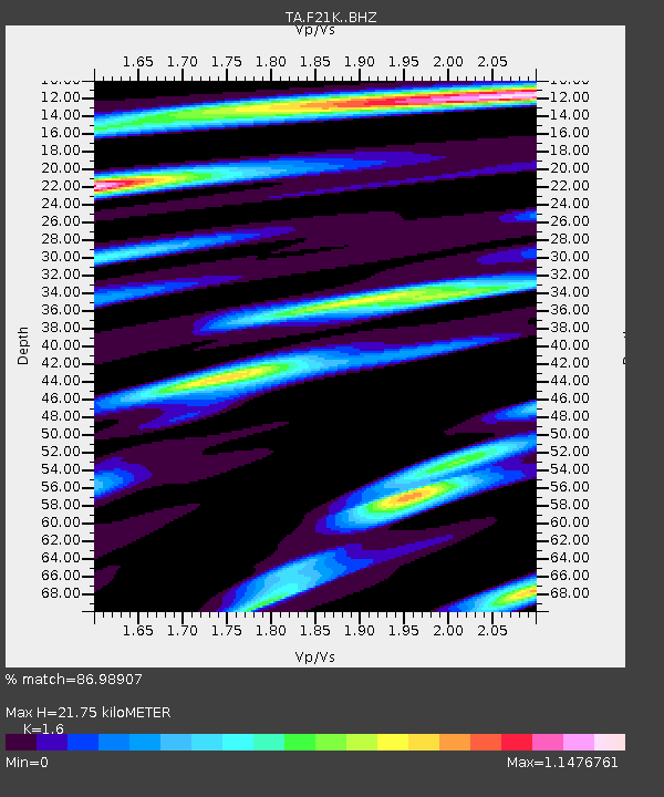
| Estimated Moho Depth: |
21.75 km |
| Estimated Crust Vp/Vs: |
1.60 |
| Assumed Crust Vp: |
6.455 km/s |
| Estimated Crust Vs: |
4.035 km/s |
| Estimated Crust Poisson's Ratio: |
0.18 |
|
| Radial Match: |
86.98907 % |
| Radial Bump: |
400 |
| Transverse Match: |
84.07698 % |
| Transverse Bump: |
400 |
| SOD ConfigId: |
11737051 |
| Insert Time: |
2019-04-25 04:34:36.082 +0000 |
| GWidth: |
2.5 |
| Max Bumps: |
400 |
| Tol: |
0.001 |
|
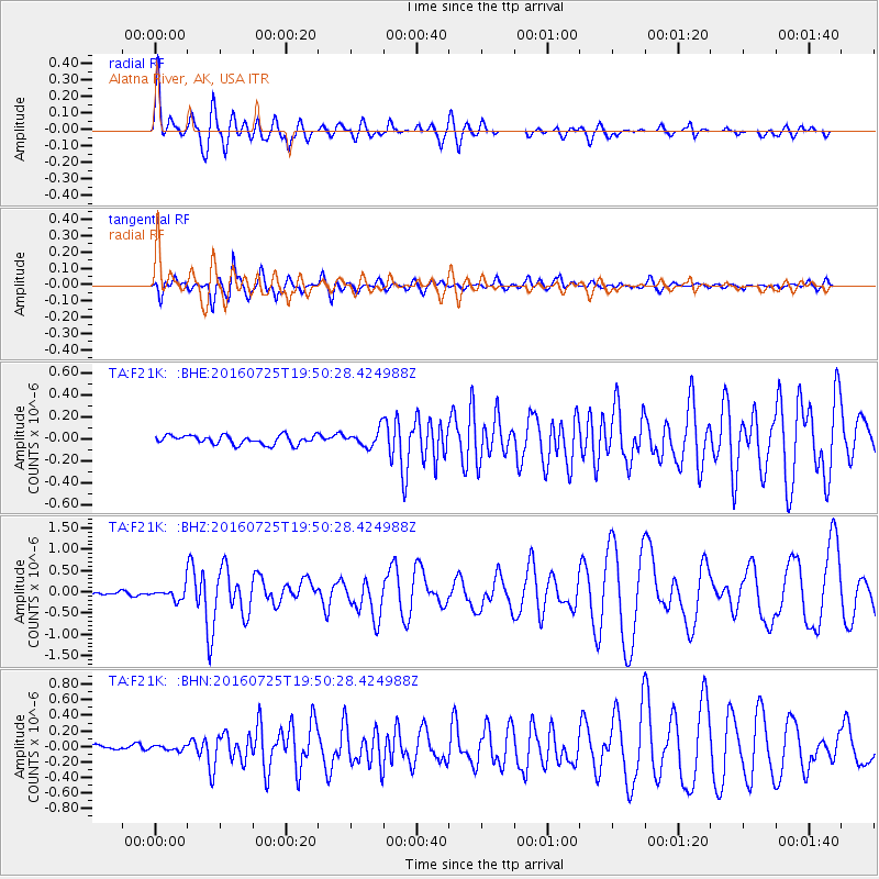
Signal To Noise
| Channel | StoN | STA | LTA |
| TA:F21K: :BHZ:20160725T19:50:28.424988Z | 5.150688 | 1.6127184E-7 | 3.1310737E-8 |
| TA:F21K: :BHN:20160725T19:50:28.424988Z | 0.95979923 | 2.9258993E-8 | 3.0484493E-8 |
| TA:F21K: :BHE:20160725T19:50:28.424988Z | 1.5696547 | 6.311138E-8 | 4.0207173E-8 |
| Arrivals |
| Ps | 2.1 SECOND |
| PpPs | 8.5 SECOND |
| PsPs/PpSs | 11 SECOND |


