You are here: Home > Network List > TA - USArray Transportable Network (new EarthScope stations) Stations List
> Station F24K Squaw Lake, AK, USA > Earthquake Result Viewer
F24K Squaw Lake, AK, USA - Earthquake Result Viewer
| Earthquake location: |
Admiralty Islands Region, P.N.G. |
| Earthquake latitude/longitude: |
-2.9/148.0 |
| Earthquake time(UTC): |
2016/07/25 (207) 19:38:44 GMT |
| Earthquake Depth: |
6.5 km |
| Earthquake Magnitude: |
6.3 MO |
| Earthquake Catalog/Contributor: |
NEIC PDE/NEIC ALERT |
|
| Network: |
TA USArray Transportable Network (new EarthScope stations) |
| Station: |
F24K Squaw Lake, AK, USA |
| Lat/Lon: |
67.52 N/147.89 W |
| Elevation: |
736 m |
|
| Distance: |
83.1 deg |
| Az: |
20.401 deg |
| Baz: |
244.855 deg |
| Ray Param: |
0.046446856 |
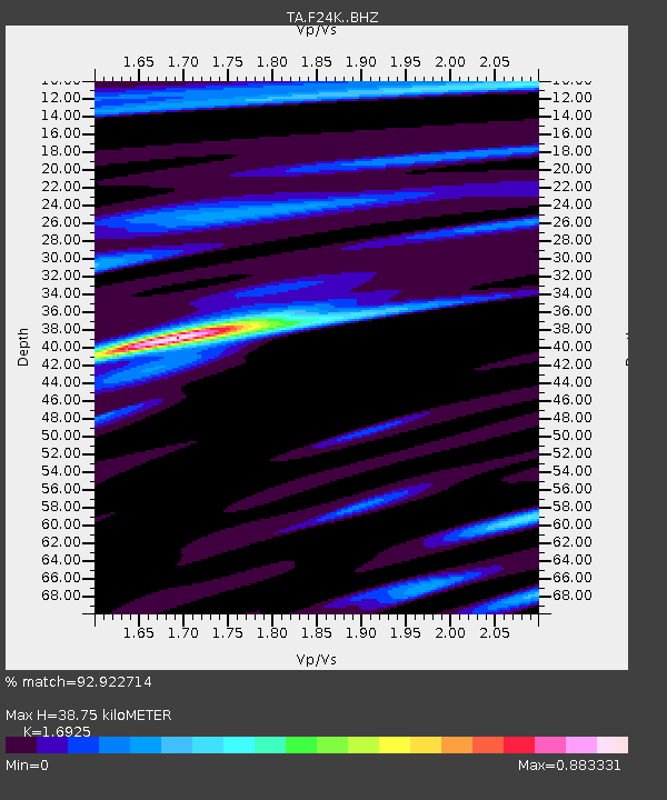
| Estimated Moho Depth: |
38.75 km |
| Estimated Crust Vp/Vs: |
1.69 |
| Assumed Crust Vp: |
6.522 km/s |
| Estimated Crust Vs: |
3.853 km/s |
| Estimated Crust Poisson's Ratio: |
0.23 |
|
| Radial Match: |
92.922714 % |
| Radial Bump: |
358 |
| Transverse Match: |
84.035545 % |
| Transverse Bump: |
400 |
| SOD ConfigId: |
11737051 |
| Insert Time: |
2019-04-25 04:34:36.618 +0000 |
| GWidth: |
2.5 |
| Max Bumps: |
400 |
| Tol: |
0.001 |
|
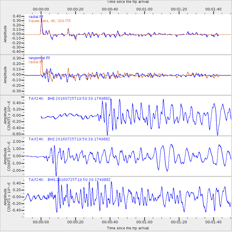
Signal To Noise
| Channel | StoN | STA | LTA |
| TA:F24K: :BHZ:20160725T19:50:39.174988Z | 3.33529 | 1.9198207E-7 | 5.7560836E-8 |
| TA:F24K: :BHN:20160725T19:50:39.174988Z | 0.74178416 | 3.8792248E-8 | 5.229587E-8 |
| TA:F24K: :BHE:20160725T19:50:39.174988Z | 0.9905862 | 4.6708415E-8 | 4.7152298E-8 |
| Arrivals |
| Ps | 4.2 SECOND |
| PpPs | 16 SECOND |
| PsPs/PpSs | 20 SECOND |


