You are here: Home > Network List > TA - USArray Transportable Network (new EarthScope stations) Stations List
> Station L27K Beaver Creek, Northway Junction, AK, USA > Earthquake Result Viewer
L27K Beaver Creek, Northway Junction, AK, USA - Earthquake Result Viewer
| Earthquake location: |
Admiralty Islands Region, P.N.G. |
| Earthquake latitude/longitude: |
-2.9/148.0 |
| Earthquake time(UTC): |
2016/07/25 (207) 19:38:44 GMT |
| Earthquake Depth: |
6.5 km |
| Earthquake Magnitude: |
6.3 MO |
| Earthquake Catalog/Contributor: |
NEIC PDE/NEIC ALERT |
|
| Network: |
TA USArray Transportable Network (new EarthScope stations) |
| Station: |
L27K Beaver Creek, Northway Junction, AK, USA |
| Lat/Lon: |
63.06 N/141.83 W |
| Elevation: |
755 m |
|
| Distance: |
83.8 deg |
| Az: |
25.535 deg |
| Baz: |
250.948 deg |
| Ray Param: |
0.045965813 |
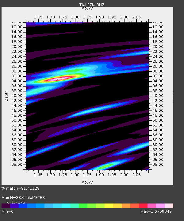
| Estimated Moho Depth: |
33.0 km |
| Estimated Crust Vp/Vs: |
1.73 |
| Assumed Crust Vp: |
6.566 km/s |
| Estimated Crust Vs: |
3.801 km/s |
| Estimated Crust Poisson's Ratio: |
0.25 |
|
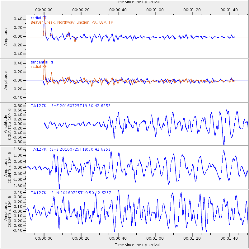
| Radial Match: |
91.41129 % |
| Radial Bump: |
396 |
| Transverse Match: |
73.256676 % |
| Transverse Bump: |
400 |
| SOD ConfigId: |
11737051 |
| Insert Time: |
2019-04-25 04:35:01.794 +0000 |
| GWidth: |
2.5 |
| Max Bumps: |
400 |
| Tol: |
0.001 |
|
Signal To Noise
| Channel | StoN | STA | LTA |
| TA:L27K: :BHZ:20160725T19:50:42.625Z | 2.7540781 | 2.1917141E-7 | 7.958068E-8 |
| TA:L27K: :BHN:20160725T19:50:42.625Z | 1.1723909 | 8.75351E-8 | 7.4663745E-8 |
| TA:L27K: :BHE:20160725T19:50:42.625Z | 1.3643792 | 9.798498E-8 | 7.181653E-8 |
| Arrivals |
| Ps | 3.8 SECOND |
| PpPs | 13 SECOND |
| PsPs/PpSs | 17 SECOND |


