You are here: Home > Network List > TA - USArray Transportable Network (new EarthScope stations) Stations List
> Station O20K Slope Mountain, AK, USA > Earthquake Result Viewer
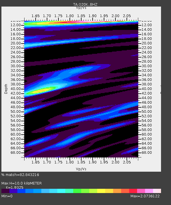
O20K Slope Mountain, AK, USA - Earthquake Result Viewer
| Earthquake location: |
Admiralty Islands Region, P.N.G. |
| Earthquake latitude/longitude: |
-2.9/148.0 |
| Earthquake time(UTC): |
2016/07/25 (207) 19:38:44 GMT |
| Earthquake Depth: |
6.5 km |
| Earthquake Magnitude: |
6.3 MO |
| Earthquake Catalog/Contributor: |
NEIC PDE/NEIC ALERT |
|
| Network: |
TA USArray Transportable Network (new EarthScope stations) |
| Station: |
O20K Slope Mountain, AK, USA |
| Lat/Lon: |
60.08 N/152.62 W |
| Elevation: |
915 m |
|
| Distance: |
77.8 deg |
| Az: |
26.192 deg |
| Baz: |
241.563 deg |
| Ray Param: |
0.05005869 |
| Estimated Moho Depth: |
10.0 km |
| Estimated Crust Vp/Vs: |
1.93 |
| Assumed Crust Vp: |
6.566 km/s |
| Estimated Crust Vs: |
3.398 km/s |
| Estimated Crust Poisson's Ratio: |
0.32 |
|
| Radial Match: |
82.843216 % |
| Radial Bump: |
400 |
| Transverse Match: |
79.64674 % |
| Transverse Bump: |
400 |
| SOD ConfigId: |
11737051 |
| Insert Time: |
2019-04-25 04:35:16.748 +0000 |
| GWidth: |
2.5 |
| Max Bumps: |
400 |
| Tol: |
0.001 |
|

Signal To Noise
| Channel | StoN | STA | LTA |
| TA:O20K: :BHZ:20160725T19:50:11.075012Z | 3.357027 | 8.014937E-7 | 2.3875103E-7 |
| TA:O20K: :BHN:20160725T19:50:11.075012Z | 1.5398961 | 3.491929E-7 | 2.2676394E-7 |
| TA:O20K: :BHE:20160725T19:50:11.075012Z | 1.2406905 | 3.078629E-7 | 2.4813835E-7 |
| Arrivals |
| Ps | 1.5 SECOND |
| PpPs | 4.3 SECOND |
| PsPs/PpSs | 5.8 SECOND |


