You are here: Home > Network List > TA - USArray Transportable Network (new EarthScope stations) Stations List
> Station P32M Atlin, BC, CAN > Earthquake Result Viewer
P32M Atlin, BC, CAN - Earthquake Result Viewer
| Earthquake location: |
Admiralty Islands Region, P.N.G. |
| Earthquake latitude/longitude: |
-2.9/148.0 |
| Earthquake time(UTC): |
2016/07/25 (207) 19:38:44 GMT |
| Earthquake Depth: |
6.5 km |
| Earthquake Magnitude: |
6.3 MO |
| Earthquake Catalog/Contributor: |
NEIC PDE/NEIC ALERT |
|
| Network: |
TA USArray Transportable Network (new EarthScope stations) |
| Station: |
P32M Atlin, BC, CAN |
| Lat/Lon: |
59.59 N/133.71 W |
| Elevation: |
793 m |
|
| Distance: |
86.6 deg |
| Az: |
29.936 deg |
| Baz: |
258.43 deg |
| Ray Param: |
0.043929942 |
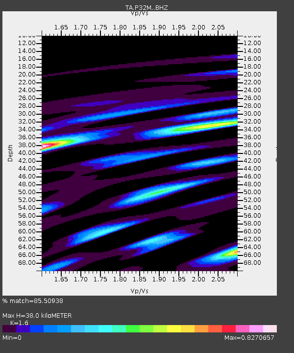
| Estimated Moho Depth: |
38.0 km |
| Estimated Crust Vp/Vs: |
1.60 |
| Assumed Crust Vp: |
6.597 km/s |
| Estimated Crust Vs: |
4.123 km/s |
| Estimated Crust Poisson's Ratio: |
0.18 |
|
| Radial Match: |
85.50938 % |
| Radial Bump: |
400 |
| Transverse Match: |
70.06503 % |
| Transverse Bump: |
400 |
| SOD ConfigId: |
11737051 |
| Insert Time: |
2019-04-25 04:35:22.891 +0000 |
| GWidth: |
2.5 |
| Max Bumps: |
400 |
| Tol: |
0.001 |
|
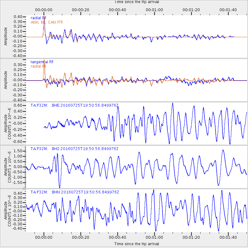
Signal To Noise
| Channel | StoN | STA | LTA |
| TA:P32M: :BHZ:20160725T19:50:56.849976Z | 1.85967 | 2.2744591E-7 | 1.2230444E-7 |
| TA:P32M: :BHN:20160725T19:50:56.849976Z | 1.3219382 | 1.6714974E-7 | 1.2644293E-7 |
| TA:P32M: :BHE:20160725T19:50:56.849976Z | 1.3479624 | 1.3029025E-7 | 9.665719E-8 |
| Arrivals |
| Ps | 3.6 SECOND |
| PpPs | 15 SECOND |
| PsPs/PpSs | 18 SECOND |


