You are here: Home > Network List > TA - USArray Transportable Network (new EarthScope stations) Stations List
> Station Q20K Shuyak Island, AK, USA > Earthquake Result Viewer
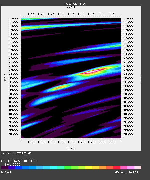
Q20K Shuyak Island, AK, USA - Earthquake Result Viewer
| Earthquake location: |
Admiralty Islands Region, P.N.G. |
| Earthquake latitude/longitude: |
-2.9/148.0 |
| Earthquake time(UTC): |
2016/07/25 (207) 19:38:44 GMT |
| Earthquake Depth: |
6.5 km |
| Earthquake Magnitude: |
6.3 MO |
| Earthquake Catalog/Contributor: |
NEIC PDE/NEIC ALERT |
|
| Network: |
TA USArray Transportable Network (new EarthScope stations) |
| Station: |
Q20K Shuyak Island, AK, USA |
| Lat/Lon: |
58.61 N/152.39 W |
| Elevation: |
180 m |
|
| Distance: |
77.2 deg |
| Az: |
27.582 deg |
| Baz: |
242.06 deg |
| Ray Param: |
0.05046229 |
| Estimated Moho Depth: |
36.5 km |
| Estimated Crust Vp/Vs: |
1.95 |
| Assumed Crust Vp: |
5.989 km/s |
| Estimated Crust Vs: |
3.067 km/s |
| Estimated Crust Poisson's Ratio: |
0.32 |
|
| Radial Match: |
92.89745 % |
| Radial Bump: |
400 |
| Transverse Match: |
84.53488 % |
| Transverse Bump: |
400 |
| SOD ConfigId: |
11737051 |
| Insert Time: |
2019-04-25 04:35:24.903 +0000 |
| GWidth: |
2.5 |
| Max Bumps: |
400 |
| Tol: |
0.001 |
|

Signal To Noise
| Channel | StoN | STA | LTA |
| TA:Q20K: :BHZ:20160725T19:50:07.750Z | 5.037355 | 6.4036686E-7 | 1.2712364E-7 |
| TA:Q20K: :BHN:20160725T19:50:07.750Z | 1.2069166 | 1.9143437E-7 | 1.5861441E-7 |
| TA:Q20K: :BHE:20160725T19:50:07.750Z | 1.728939 | 2.5172244E-7 | 1.4559359E-7 |
| Arrivals |
| Ps | 5.9 SECOND |
| PpPs | 18 SECOND |
| PsPs/PpSs | 24 SECOND |


