You are here: Home > Network List > TA - USArray Transportable Network (new EarthScope stations) Stations List
> Station S12K Black Hills, AK, USA > Earthquake Result Viewer
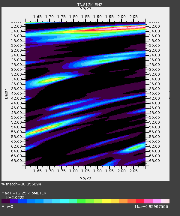
S12K Black Hills, AK, USA - Earthquake Result Viewer
| Earthquake location: |
Admiralty Islands Region, P.N.G. |
| Earthquake latitude/longitude: |
-2.9/148.0 |
| Earthquake time(UTC): |
2016/07/25 (207) 19:38:44 GMT |
| Earthquake Depth: |
6.5 km |
| Earthquake Magnitude: |
6.3 MO |
| Earthquake Catalog/Contributor: |
NEIC PDE/NEIC ALERT |
|
| Network: |
TA USArray Transportable Network (new EarthScope stations) |
| Station: |
S12K Black Hills, AK, USA |
| Lat/Lon: |
55.70 N/162.06 W |
| Elevation: |
411 m |
|
| Distance: |
71.2 deg |
| Az: |
27.239 deg |
| Baz: |
233.853 deg |
| Ray Param: |
0.054464962 |
| Estimated Moho Depth: |
12.25 km |
| Estimated Crust Vp/Vs: |
2.02 |
| Assumed Crust Vp: |
5.989 km/s |
| Estimated Crust Vs: |
2.961 km/s |
| Estimated Crust Poisson's Ratio: |
0.34 |
|
| Radial Match: |
88.056694 % |
| Radial Bump: |
400 |
| Transverse Match: |
77.473206 % |
| Transverse Bump: |
400 |
| SOD ConfigId: |
11737051 |
| Insert Time: |
2019-04-25 04:35:28.199 +0000 |
| GWidth: |
2.5 |
| Max Bumps: |
400 |
| Tol: |
0.001 |
|

Signal To Noise
| Channel | StoN | STA | LTA |
| TA:S12K: :BHZ:20160725T19:49:32.849976Z | 4.295171 | 1.1461801E-6 | 2.6685322E-7 |
| TA:S12K: :BHN:20160725T19:49:32.849976Z | 2.2648907 | 4.696862E-7 | 2.0737698E-7 |
| TA:S12K: :BHE:20160725T19:49:32.849976Z | 2.2098677 | 5.207261E-7 | 2.3563679E-7 |
| Arrivals |
| Ps | 2.1 SECOND |
| PpPs | 6.0 SECOND |
| PsPs/PpSs | 8.2 SECOND |


