You are here: Home > Network List > NE - New England Seismic Network Stations List
> Station WSPT Westport, CT, USA > Earthquake Result Viewer
WSPT Westport, CT, USA - Earthquake Result Viewer
| Earthquake location: |
Near Coast Of Central Chile |
| Earthquake latitude/longitude: |
-31.5/-71.8 |
| Earthquake time(UTC): |
2015/09/17 (260) 04:10:31 GMT |
| Earthquake Depth: |
40 km |
| Earthquake Magnitude: |
6.3 MB |
| Earthquake Catalog/Contributor: |
NEIC PDE/NEIC COMCAT |
|
| Network: |
NE New England Seismic Network |
| Station: |
WSPT Westport, CT, USA |
| Lat/Lon: |
41.17 N/73.33 W |
| Elevation: |
91 m |
|
| Distance: |
72.4 deg |
| Az: |
358.767 deg |
| Baz: |
178.605 deg |
| Ray Param: |
0.0536484 |
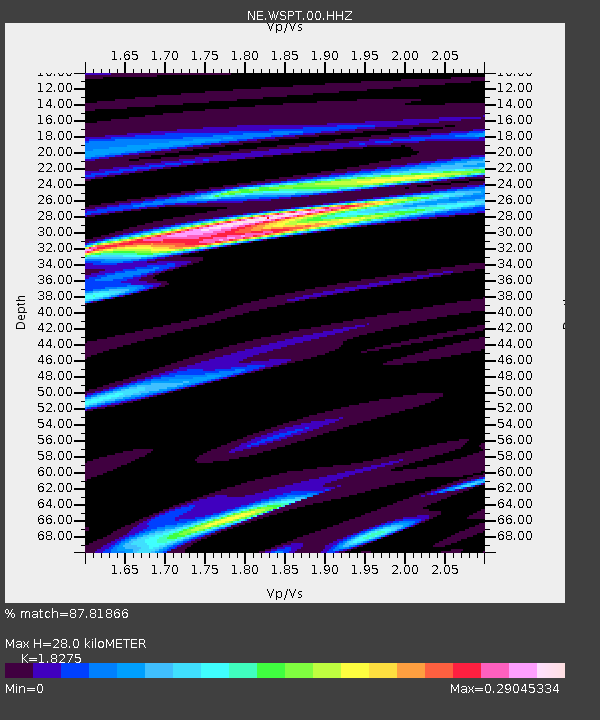
| Estimated Moho Depth: |
28.0 km |
| Estimated Crust Vp/Vs: |
1.83 |
| Assumed Crust Vp: |
6.472 km/s |
| Estimated Crust Vs: |
3.541 km/s |
| Estimated Crust Poisson's Ratio: |
0.29 |
|
| Radial Match: |
87.81866 % |
| Radial Bump: |
264 |
| Transverse Match: |
54.086437 % |
| Transverse Bump: |
400 |
| SOD ConfigId: |
1156111 |
| Insert Time: |
2015-10-01 04:37:06.084 +0000 |
| GWidth: |
2.5 |
| Max Bumps: |
400 |
| Tol: |
0.001 |
|

Signal To Noise
| Channel | StoN | STA | LTA |
| NE:WSPT:00:HHZ:20150917T04:21:21.799011Z | 7.1583357 | 3.0134906E-6 | 4.2097645E-7 |
| NE:WSPT:00:HH1:20150917T04:21:21.799011Z | 2.1342933 | 8.006878E-7 | 3.7515358E-7 |
| NE:WSPT:00:HH2:20150917T04:21:21.799011Z | 1.6866928 | 7.4072994E-7 | 4.391611E-7 |
| Arrivals |
| Ps | 3.7 SECOND |
| PpPs | 12 SECOND |
| PsPs/PpSs | 16 SECOND |


