You are here: Home > Network List > YT07 - POLENET Stations List
> Station CLRK CLRK > Earthquake Result Viewer
CLRK CLRK - Earthquake Result Viewer
| Earthquake location: |
Admiralty Islands Region, P.N.G. |
| Earthquake latitude/longitude: |
-2.9/148.0 |
| Earthquake time(UTC): |
2016/07/25 (207) 19:38:44 GMT |
| Earthquake Depth: |
6.5 km |
| Earthquake Magnitude: |
6.3 MO |
| Earthquake Catalog/Contributor: |
NEIC PDE/NEIC ALERT |
|
| Network: |
YT POLENET |
| Station: |
CLRK CLRK |
| Lat/Lon: |
77.32 S/141.85 W |
| Elevation: |
1043 m |
|
| Distance: |
82.8 deg |
| Az: |
167.913 deg |
| Baz: |
288.761 deg |
| Ray Param: |
0.046611235 |
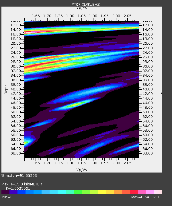
| Estimated Moho Depth: |
15.0 km |
| Estimated Crust Vp/Vs: |
1.60 |
| Assumed Crust Vp: |
6.182 km/s |
| Estimated Crust Vs: |
3.857 km/s |
| Estimated Crust Poisson's Ratio: |
0.18 |
|
| Radial Match: |
91.65293 % |
| Radial Bump: |
400 |
| Transverse Match: |
74.41665 % |
| Transverse Bump: |
400 |
| SOD ConfigId: |
11737051 |
| Insert Time: |
2019-04-25 04:36:57.821 +0000 |
| GWidth: |
2.5 |
| Max Bumps: |
400 |
| Tol: |
0.001 |
|

Signal To Noise
| Channel | StoN | STA | LTA |
| YT:CLRK: :BHZ:20160725T19:50:37.749023Z | 1.7577858 | 2.8317646E-7 | 1.610984E-7 |
| YT:CLRK: :BHN:20160725T19:50:37.749023Z | 1.0961684 | 1.348067E-7 | 1.2297991E-7 |
| YT:CLRK: :BHE:20160725T19:50:37.749023Z | 2.2615983 | 1.5828945E-7 | 6.999008E-8 |
| Arrivals |
| Ps | 1.5 SECOND |
| PpPs | 6.1 SECOND |
| PsPs/PpSs | 7.7 SECOND |


