You are here: Home > Network List > US - United States National Seismic Network Stations List
> Station BINY Binghamton, New York, USA > Earthquake Result Viewer
BINY Binghamton, New York, USA - Earthquake Result Viewer
| Earthquake location: |
Near Coast Of Nicaragua |
| Earthquake latitude/longitude: |
11.4/-86.7 |
| Earthquake time(UTC): |
2004/10/09 (283) 21:26:53 GMT |
| Earthquake Depth: |
35 km |
| Earthquake Magnitude: |
6.0 MB, 7.0 MS, 6.9 MW, 6.8 MW |
| Earthquake Catalog/Contributor: |
WHDF/NEIC |
|
| Network: |
US United States National Seismic Network |
| Station: |
BINY Binghamton, New York, USA |
| Lat/Lon: |
42.20 N/75.99 W |
| Elevation: |
498 m |
|
| Distance: |
32.0 deg |
| Az: |
15.039 deg |
| Baz: |
200.022 deg |
| Ray Param: |
0.07876258 |
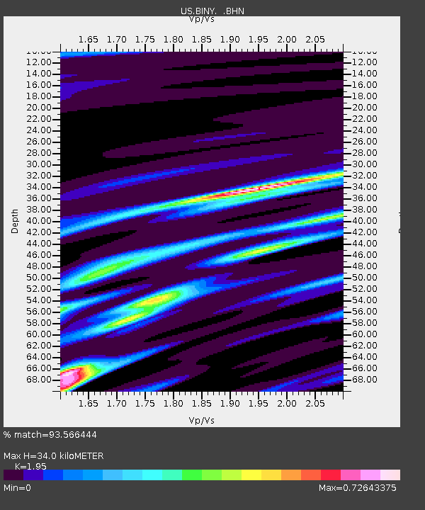
| Estimated Moho Depth: |
34.0 km |
| Estimated Crust Vp/Vs: |
1.95 |
| Assumed Crust Vp: |
6.419 km/s |
| Estimated Crust Vs: |
3.292 km/s |
| Estimated Crust Poisson's Ratio: |
0.32 |
|
| Radial Match: |
93.566444 % |
| Radial Bump: |
285 |
| Transverse Match: |
67.93861 % |
| Transverse Bump: |
400 |
| SOD ConfigId: |
110177 |
| Insert Time: |
2010-03-05 05:45:56.738 +0000 |
| GWidth: |
2.5 |
| Max Bumps: |
400 |
| Tol: |
0.001 |
|

Signal To Noise
| Channel | StoN | STA | LTA |
| US:BINY: :BHN:20041009T21:32:46.828Z | 14.551584 | 2.2073907E-6 | 1.5169418E-7 |
| US:BINY: :BHE:20041009T21:32:46.828Z | 7.4690604 | 9.5226045E-7 | 1.27494E-7 |
| US:BINY: :BHZ:20041009T21:32:46.828Z | 16.812014 | 4.176851E-6 | 2.4844442E-7 |
| Arrivals |
| Ps | 5.4 SECOND |
| PpPs | 15 SECOND |
| PsPs/PpSs | 20 SECOND |


