You are here: Home > Network List > US - United States National Seismic Network Stations List
> Station BINY Binghamton, New York, USA > Earthquake Result Viewer
BINY Binghamton, New York, USA - Earthquake Result Viewer
| Earthquake location: |
Hokkaido, Japan Region |
| Earthquake latitude/longitude: |
43.0/145.1 |
| Earthquake time(UTC): |
2004/11/28 (333) 18:32:14 GMT |
| Earthquake Depth: |
39 km |
| Earthquake Magnitude: |
6.4 MB, 6.7 MS, 7.0 MW, 7.0 MW |
| Earthquake Catalog/Contributor: |
WHDF/NEIC |
|
| Network: |
US United States National Seismic Network |
| Station: |
BINY Binghamton, New York, USA |
| Lat/Lon: |
42.20 N/75.99 W |
| Elevation: |
498 m |
|
| Distance: |
87.5 deg |
| Az: |
29.274 deg |
| Baz: |
331.135 deg |
| Ray Param: |
0.043247607 |
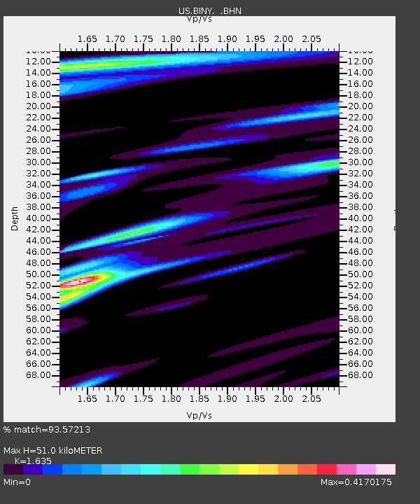
| Estimated Moho Depth: |
51.0 km |
| Estimated Crust Vp/Vs: |
1.63 |
| Assumed Crust Vp: |
6.419 km/s |
| Estimated Crust Vs: |
3.926 km/s |
| Estimated Crust Poisson's Ratio: |
0.20 |
|
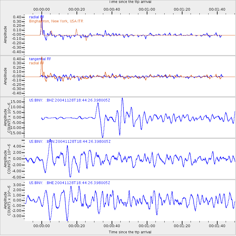
| Radial Match: |
93.57213 % |
| Radial Bump: |
371 |
| Transverse Match: |
82.646576 % |
| Transverse Bump: |
400 |
| SOD ConfigId: |
110177 |
| Insert Time: |
2010-03-05 05:45:59.363 +0000 |
| GWidth: |
2.5 |
| Max Bumps: |
400 |
| Tol: |
0.001 |
|
Signal To Noise
| Channel | StoN | STA | LTA |
| US:BINY: :BHN:20041128T18:44:26.398005Z | 6.9126563 | 2.8331158E-6 | 4.0984474E-7 |
| US:BINY: :BHE:20041128T18:44:26.398005Z | 3.7051988 | 1.582807E-6 | 4.2718548E-7 |
| US:BINY: :BHZ:20041128T18:44:26.398005Z | 16.105516 | 9.119907E-6 | 5.6625987E-7 |
| Arrivals |
| Ps | 5.2 SECOND |
| PpPs | 20 SECOND |
| PsPs/PpSs | 26 SECOND |


