You are here: Home > Network List > TA - USArray Transportable Network (new EarthScope stations) Stations List
> Station F21K Alatna River, AK, USA > Earthquake Result Viewer
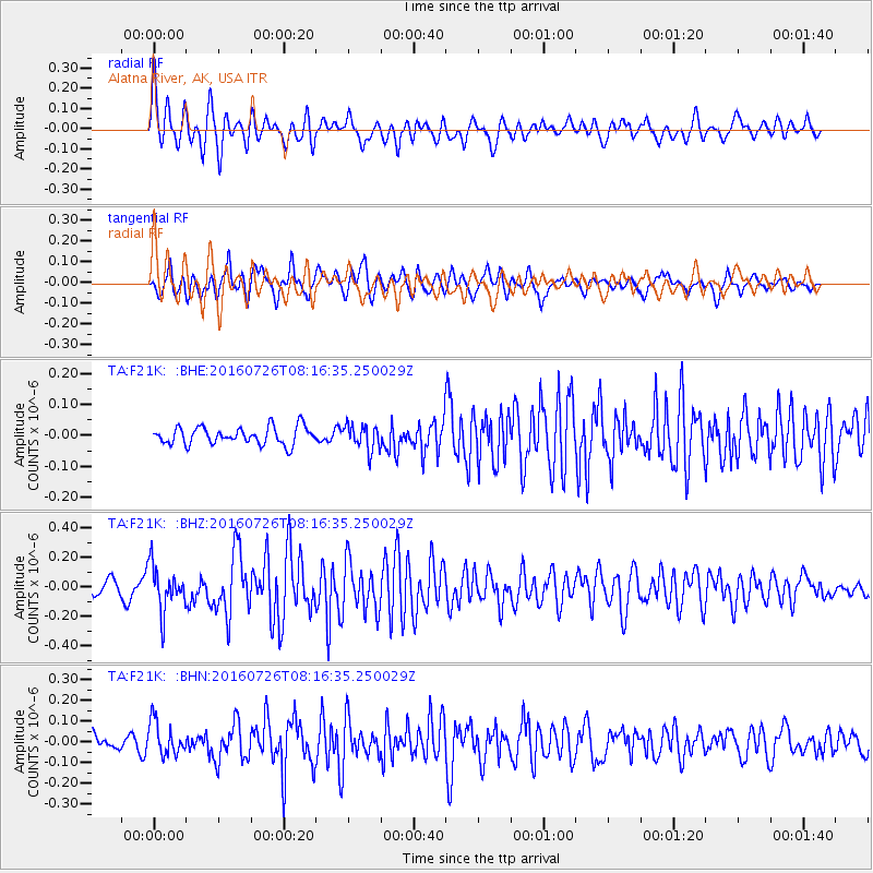
F21K Alatna River, AK, USA - Earthquake Result Viewer
*The percent match for this event was below the threshold and hence no stack was calculated.
| Earthquake location: |
Vanuatu Islands |
| Earthquake latitude/longitude: |
-16.0/167.5 |
| Earthquake time(UTC): |
2016/07/26 (208) 08:04:20 GMT |
| Earthquake Depth: |
32 km |
| Earthquake Magnitude: |
5.8 MWW, 5.6 MWB, 5.7 MWC |
| Earthquake Catalog/Contributor: |
NEIC PDE/NEIC COMCAT |
|
| Network: |
TA USArray Transportable Network (new EarthScope stations) |
| Station: |
F21K Alatna River, AK, USA |
| Lat/Lon: |
67.22 N/153.48 W |
| Elevation: |
597 m |
|
| Distance: |
87.8 deg |
| Az: |
14.215 deg |
| Baz: |
217.332 deg |
| Ray Param: |
$rayparam |
*The percent match for this event was below the threshold and hence was not used in the summary stack. |
|
| Radial Match: |
77.154724 % |
| Radial Bump: |
400 |
| Transverse Match: |
79.80161 % |
| Transverse Bump: |
400 |
| SOD ConfigId: |
11737051 |
| Insert Time: |
2019-04-25 04:42:13.617 +0000 |
| GWidth: |
2.5 |
| Max Bumps: |
400 |
| Tol: |
0.001 |
|
Signal To Noise
| Channel | StoN | STA | LTA |
| TA:F21K: :BHZ:20160726T08:16:35.250029Z | 2.8339503 | 1.526462E-7 | 5.38634E-8 |
| TA:F21K: :BHN:20160726T08:16:35.250029Z | 2.521711 | 8.0229384E-8 | 3.1815453E-8 |
| TA:F21K: :BHE:20160726T08:16:35.250029Z | 1.4193475 | 4.019942E-8 | 2.8322464E-8 |
| Arrivals |
| Ps | |
| PpPs | |
| PsPs/PpSs | |


