You are here: Home > Network List > TA - USArray Transportable Network (new EarthScope stations) Stations List
> Station L20K Farewell, AK, USA > Earthquake Result Viewer
L20K Farewell, AK, USA - Earthquake Result Viewer
| Earthquake location: |
Vanuatu Islands |
| Earthquake latitude/longitude: |
-16.0/167.5 |
| Earthquake time(UTC): |
2016/07/26 (208) 08:04:20 GMT |
| Earthquake Depth: |
32 km |
| Earthquake Magnitude: |
5.8 MWW, 5.6 MWB, 5.7 MWC |
| Earthquake Catalog/Contributor: |
NEIC PDE/NEIC COMCAT |
|
| Network: |
TA USArray Transportable Network (new EarthScope stations) |
| Station: |
L20K Farewell, AK, USA |
| Lat/Lon: |
62.48 N/153.88 W |
| Elevation: |
673 m |
|
| Distance: |
83.9 deg |
| Az: |
16.97 deg |
| Baz: |
217.172 deg |
| Ray Param: |
0.045794874 |
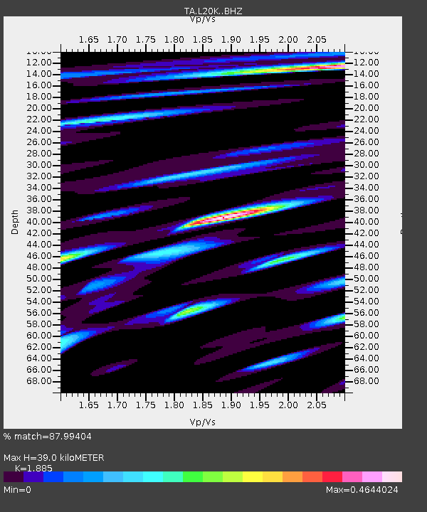
| Estimated Moho Depth: |
39.0 km |
| Estimated Crust Vp/Vs: |
1.88 |
| Assumed Crust Vp: |
6.566 km/s |
| Estimated Crust Vs: |
3.483 km/s |
| Estimated Crust Poisson's Ratio: |
0.30 |
|
| Radial Match: |
87.99404 % |
| Radial Bump: |
400 |
| Transverse Match: |
74.14567 % |
| Transverse Bump: |
400 |
| SOD ConfigId: |
11737051 |
| Insert Time: |
2019-04-25 04:42:30.172 +0000 |
| GWidth: |
2.5 |
| Max Bumps: |
400 |
| Tol: |
0.001 |
|

Signal To Noise
| Channel | StoN | STA | LTA |
| TA:L20K: :BHZ:20160726T08:16:16.050017Z | 14.106008 | 8.8221856E-7 | 6.254204E-8 |
| TA:L20K: :BHN:20160726T08:16:16.050017Z | 3.926071 | 3.135371E-7 | 7.986027E-8 |
| TA:L20K: :BHE:20160726T08:16:16.050017Z | 2.3269196 | 2.5136248E-7 | 1.08023706E-7 |
| Arrivals |
| Ps | 5.4 SECOND |
| PpPs | 17 SECOND |
| PsPs/PpSs | 22 SECOND |


