You are here: Home > Network List > TA - USArray Transportable Network (new EarthScope stations) Stations List
> Station M19K Big River Lodge, Big River, AK, USA > Earthquake Result Viewer
M19K Big River Lodge, Big River, AK, USA - Earthquake Result Viewer
| Earthquake location: |
Vanuatu Islands |
| Earthquake latitude/longitude: |
-16.0/167.5 |
| Earthquake time(UTC): |
2016/07/26 (208) 08:04:20 GMT |
| Earthquake Depth: |
32 km |
| Earthquake Magnitude: |
5.8 MWW, 5.6 MWB, 5.7 MWC |
| Earthquake Catalog/Contributor: |
NEIC PDE/NEIC COMCAT |
|
| Network: |
TA USArray Transportable Network (new EarthScope stations) |
| Station: |
M19K Big River Lodge, Big River, AK, USA |
| Lat/Lon: |
61.90 N/154.39 W |
| Elevation: |
521 m |
|
| Distance: |
83.3 deg |
| Az: |
17.126 deg |
| Baz: |
216.737 deg |
| Ray Param: |
0.046226095 |
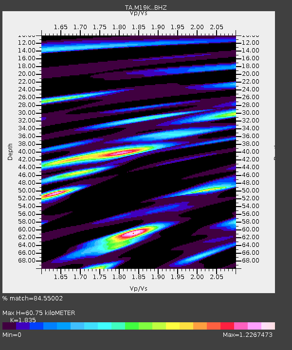
| Estimated Moho Depth: |
60.75 km |
| Estimated Crust Vp/Vs: |
1.84 |
| Assumed Crust Vp: |
6.566 km/s |
| Estimated Crust Vs: |
3.578 km/s |
| Estimated Crust Poisson's Ratio: |
0.29 |
|
| Radial Match: |
84.55002 % |
| Radial Bump: |
400 |
| Transverse Match: |
75.258064 % |
| Transverse Bump: |
400 |
| SOD ConfigId: |
11737051 |
| Insert Time: |
2019-04-25 04:42:30.793 +0000 |
| GWidth: |
2.5 |
| Max Bumps: |
400 |
| Tol: |
0.001 |
|

Signal To Noise
| Channel | StoN | STA | LTA |
| TA:M19K: :BHZ:20160726T08:16:12.94998Z | 3.7019615 | 2.972194E-7 | 8.0287E-8 |
| TA:M19K: :BHN:20160726T08:16:12.94998Z | 3.217784 | 1.6042345E-7 | 4.985526E-8 |
| TA:M19K: :BHE:20160726T08:16:12.94998Z | 1.8591312 | 8.800256E-8 | 4.7335313E-8 |
| Arrivals |
| Ps | 7.9 SECOND |
| PpPs | 26 SECOND |
| PsPs/PpSs | 33 SECOND |


