You are here: Home > Network List > TA - USArray Transportable Network (new EarthScope stations) Stations List
> Station O18K Koktuh Hills, AK, USA > Earthquake Result Viewer
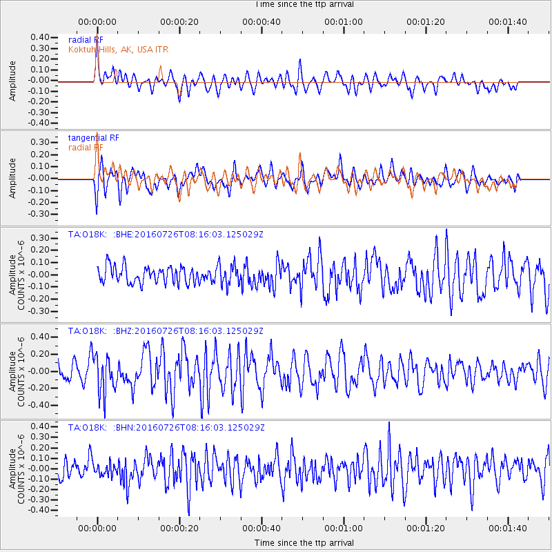
O18K Koktuh Hills, AK, USA - Earthquake Result Viewer
*The percent match for this event was below the threshold and hence no stack was calculated.
| Earthquake location: |
Vanuatu Islands |
| Earthquake latitude/longitude: |
-16.0/167.5 |
| Earthquake time(UTC): |
2016/07/26 (208) 08:04:20 GMT |
| Earthquake Depth: |
32 km |
| Earthquake Magnitude: |
5.8 MWW, 5.6 MWB, 5.7 MWC |
| Earthquake Catalog/Contributor: |
NEIC PDE/NEIC COMCAT |
|
| Network: |
TA USArray Transportable Network (new EarthScope stations) |
| Station: |
O18K Koktuh Hills, AK, USA |
| Lat/Lon: |
59.85 N/155.21 W |
| Elevation: |
544 m |
|
| Distance: |
81.4 deg |
| Az: |
18.035 deg |
| Baz: |
216.145 deg |
| Ray Param: |
$rayparam |
*The percent match for this event was below the threshold and hence was not used in the summary stack. |
|
| Radial Match: |
64.18524 % |
| Radial Bump: |
400 |
| Transverse Match: |
66.01464 % |
| Transverse Bump: |
400 |
| SOD ConfigId: |
11737051 |
| Insert Time: |
2019-04-25 04:42:39.696 +0000 |
| GWidth: |
2.5 |
| Max Bumps: |
400 |
| Tol: |
0.001 |
|
Signal To Noise
| Channel | StoN | STA | LTA |
| TA:O18K: :BHZ:20160726T08:16:03.125029Z | 2.0611115 | 2.0806343E-7 | 1.009472E-7 |
| TA:O18K: :BHN:20160726T08:16:03.125029Z | 0.51376784 | 4.8631858E-8 | 9.465727E-8 |
| TA:O18K: :BHE:20160726T08:16:03.125029Z | 1.2504996 | 8.457737E-8 | 6.7634865E-8 |
| Arrivals |
| Ps | |
| PpPs | |
| PsPs/PpSs | |


