You are here: Home > Network List > US - United States National Seismic Network Stations List
> Station BINY Binghamton, New York, USA > Earthquake Result Viewer
BINY Binghamton, New York, USA - Earthquake Result Viewer
| Earthquake location: |
Kuril Islands |
| Earthquake latitude/longitude: |
47.1/153.5 |
| Earthquake time(UTC): |
2006/11/15 (319) 21:25:22 GMT |
| Earthquake Depth: |
10 km |
| Earthquake Magnitude: |
5.7 MB |
| Earthquake Catalog/Contributor: |
WHDF/NEIC |
|
| Network: |
US United States National Seismic Network |
| Station: |
BINY Binghamton, New York, USA |
| Lat/Lon: |
42.20 N/75.99 W |
| Elevation: |
498 m |
|
| Distance: |
80.8 deg |
| Az: |
34.912 deg |
| Baz: |
328.278 deg |
| Ray Param: |
0.048019584 |
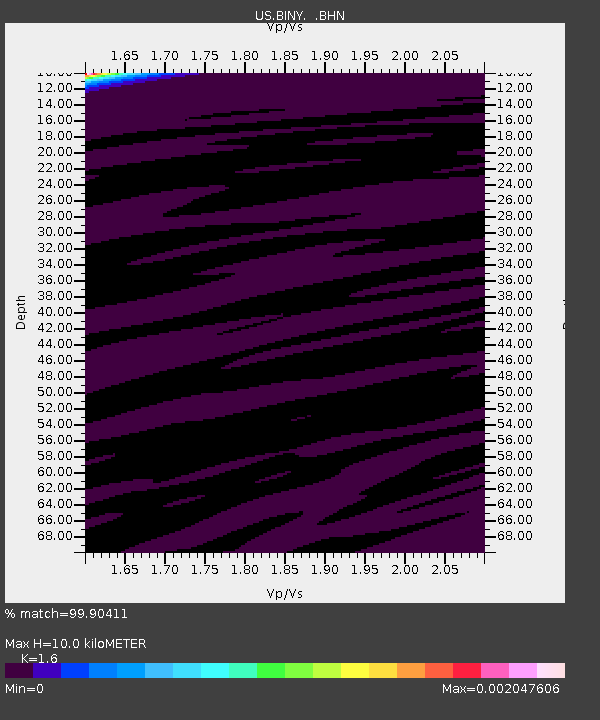
| Estimated Moho Depth: |
10.0 km |
| Estimated Crust Vp/Vs: |
1.60 |
| Assumed Crust Vp: |
6.419 km/s |
| Estimated Crust Vs: |
4.012 km/s |
| Estimated Crust Poisson's Ratio: |
0.18 |
|
| Radial Match: |
99.90411 % |
| Radial Bump: |
16 |
| Transverse Match: |
81.799385 % |
| Transverse Bump: |
99 |
| SOD ConfigId: |
2564 |
| Insert Time: |
2010-03-05 05:47:54.556 +0000 |
| GWidth: |
2.5 |
| Max Bumps: |
400 |
| Tol: |
0.001 |
|

Signal To Noise
| Channel | StoN | STA | LTA |
| US:BINY: :BHN:20061115T21:37:04.933015Z | 1.0335089 | 7.124911E-7 | 6.893904E-7 |
| US:BINY: :BHE:20061115T21:37:04.933015Z | 0.9418167 | 3.9357752E-7 | 4.1789184E-7 |
| US:BINY: :BHZ:20061115T21:37:04.933015Z | 0.83869785 | 5.1568986E-7 | 6.148697E-7 |
| Arrivals |
| Ps | 1.0 SECOND |
| PpPs | 3.9 SECOND |
| PsPs/PpSs | 4.9 SECOND |


