You are here: Home > Network List > US - United States National Seismic Network Stations List
> Station BINY Binghamton, New York, USA > Earthquake Result Viewer
BINY Binghamton, New York, USA - Earthquake Result Viewer
| Earthquake location: |
East Of Kuril Islands |
| Earthquake latitude/longitude: |
47.1/155.2 |
| Earthquake time(UTC): |
2006/11/15 (319) 19:28:06 GMT |
| Earthquake Depth: |
10 km |
| Earthquake Magnitude: |
5.5 MB |
| Earthquake Catalog/Contributor: |
WHDF/NEIC |
|
| Network: |
US United States National Seismic Network |
| Station: |
BINY Binghamton, New York, USA |
| Lat/Lon: |
42.20 N/75.99 W |
| Elevation: |
498 m |
|
| Distance: |
80.2 deg |
| Az: |
35.962 deg |
| Baz: |
327.305 deg |
| Ray Param: |
0.04842881 |
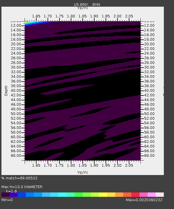
| Estimated Moho Depth: |
10.0 km |
| Estimated Crust Vp/Vs: |
1.60 |
| Assumed Crust Vp: |
6.419 km/s |
| Estimated Crust Vs: |
4.012 km/s |
| Estimated Crust Poisson's Ratio: |
0.18 |
|
| Radial Match: |
99.88532 % |
| Radial Bump: |
6 |
| Transverse Match: |
92.6156 % |
| Transverse Bump: |
97 |
| SOD ConfigId: |
2564 |
| Insert Time: |
2010-03-05 05:47:56.363 +0000 |
| GWidth: |
2.5 |
| Max Bumps: |
400 |
| Tol: |
0.001 |
|

Signal To Noise
| Channel | StoN | STA | LTA |
| US:BINY: :BHN:20061115T19:39:45.55803Z | 0.94260854 | 6.4087993E-7 | 6.799004E-7 |
| US:BINY: :BHE:20061115T19:39:45.55803Z | 1.0604362 | 4.7214513E-7 | 4.4523668E-7 |
| US:BINY: :BHZ:20061115T19:39:45.55803Z | 0.87491727 | 4.9168614E-7 | 5.619802E-7 |
| Arrivals |
| Ps | 1.0 SECOND |
| PpPs | 3.9 SECOND |
| PsPs/PpSs | 4.9 SECOND |


