You are here: Home > Network List > US - United States National Seismic Network Stations List
> Station BINY Binghamton, New York, USA > Earthquake Result Viewer
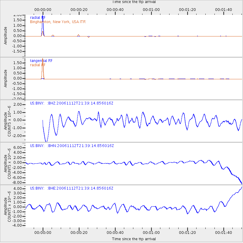
BINY Binghamton, New York, USA - Earthquake Result Viewer

| Earthquake location: |
Kuril Islands |
| Earthquake latitude/longitude: |
48.3/154.2 |
| Earthquake time(UTC): |
2006/11/12 (316) 21:27:42 GMT |
| Earthquake Depth: |
36 km |
| Earthquake Magnitude: |
6.1 MB, 5.4 MS, 5.9 MW, 5.9 MW |
| Earthquake Catalog/Contributor: |
WHDF/NEIC |
|
| Network: |
US United States National Seismic Network |
| Station: |
BINY Binghamton, New York, USA |
| Lat/Lon: |
42.20 N/75.99 W |
| Elevation: |
498 m |
|
| Distance: |
79.6 deg |
| Az: |
35.499 deg |
| Baz: |
328.533 deg |
| Ray Param: |
0.048798587 |
| Estimated Moho Depth: |
10.0 km |
| Estimated Crust Vp/Vs: |
1.60 |
| Assumed Crust Vp: |
6.419 km/s |
| Estimated Crust Vs: |
4.012 km/s |
| Estimated Crust Poisson's Ratio: |
0.18 |
|
| Radial Match: |
99.696724 % |
| Radial Bump: |
29 |
| Transverse Match: |
69.058586 % |
| Transverse Bump: |
226 |
| SOD ConfigId: |
2564 |
| Insert Time: |
2010-03-05 05:48:01.132 +0000 |
| GWidth: |
2.5 |
| Max Bumps: |
400 |
| Tol: |
0.001 |
|
Signal To Noise
| Channel | StoN | STA | LTA |
| US:BINY: :BHN:20061112T21:39:14.856016Z | 0.88329697 | 7.1388087E-7 | 8.082003E-7 |
| US:BINY: :BHE:20061112T21:39:14.856016Z | 1.0927622 | 6.7592026E-7 | 6.185428E-7 |
| US:BINY: :BHZ:20061112T21:39:14.856016Z | 0.6648919 | 6.2281464E-7 | 9.3671565E-7 |
| Arrivals |
| Ps | 1.0 SECOND |
| PpPs | 3.9 SECOND |
| PsPs/PpSs | 4.9 SECOND |


