You are here: Home > Network List > AK - Alaska Regional Network Stations List
> Station NEA2 Nenana, AK, USA > Earthquake Result Viewer
NEA2 Nenana, AK, USA - Earthquake Result Viewer
| Earthquake location: |
Mariana Islands |
| Earthquake latitude/longitude: |
18.5/145.5 |
| Earthquake time(UTC): |
2016/07/29 (211) 21:18:25 GMT |
| Earthquake Depth: |
212 km |
| Earthquake Magnitude: |
7.7 MWW, 7.7 MWB, 7.7 MI |
| Earthquake Catalog/Contributor: |
NEIC PDE/NEIC COMCAT |
|
| Network: |
AK Alaska Regional Network |
| Station: |
NEA2 Nenana, AK, USA |
| Lat/Lon: |
64.59 N/149.07 W |
| Elevation: |
450 m |
|
| Distance: |
62.9 deg |
| Az: |
26.138 deg |
| Baz: |
255.684 deg |
| Ray Param: |
0.05925419 |
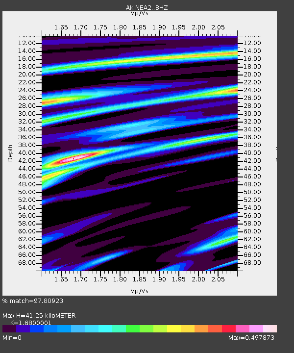
| Estimated Moho Depth: |
41.25 km |
| Estimated Crust Vp/Vs: |
1.68 |
| Assumed Crust Vp: |
6.566 km/s |
| Estimated Crust Vs: |
3.908 km/s |
| Estimated Crust Poisson's Ratio: |
0.23 |
|
| Radial Match: |
97.80923 % |
| Radial Bump: |
267 |
| Transverse Match: |
89.22698 % |
| Transverse Bump: |
400 |
| SOD ConfigId: |
11737051 |
| Insert Time: |
2019-04-25 04:53:43.971 +0000 |
| GWidth: |
2.5 |
| Max Bumps: |
400 |
| Tol: |
0.001 |
|

Signal To Noise
| Channel | StoN | STA | LTA |
| AK:NEA2: :BHZ:20160729T21:27:59.659985Z | 96.00483 | 1.1063533E-5 | 1.1523933E-7 |
| AK:NEA2: :BHN:20160729T21:27:59.659985Z | 46.857838 | 2.8960449E-6 | 6.180492E-8 |
| AK:NEA2: :BHE:20160729T21:27:59.659985Z | 44.93331 | 4.0471505E-6 | 9.007016E-8 |
| Arrivals |
| Ps | 4.5 SECOND |
| PpPs | 16 SECOND |
| PsPs/PpSs | 21 SECOND |


