You are here: Home > Network List > AK - Alaska Regional Network Stations List
> Station SUCK Suckling Hills, AK, USA > Earthquake Result Viewer
SUCK Suckling Hills, AK, USA - Earthquake Result Viewer
| Earthquake location: |
Mariana Islands |
| Earthquake latitude/longitude: |
18.5/145.5 |
| Earthquake time(UTC): |
2016/07/29 (211) 21:18:25 GMT |
| Earthquake Depth: |
212 km |
| Earthquake Magnitude: |
7.7 MWW, 7.7 MWB, 7.7 MI |
| Earthquake Catalog/Contributor: |
NEIC PDE/NEIC COMCAT |
|
| Network: |
AK Alaska Regional Network |
| Station: |
SUCK Suckling Hills, AK, USA |
| Lat/Lon: |
60.07 N/143.78 W |
| Elevation: |
467 m |
|
| Distance: |
64.5 deg |
| Az: |
31.619 deg |
| Baz: |
262.797 deg |
| Ray Param: |
0.05823803 |
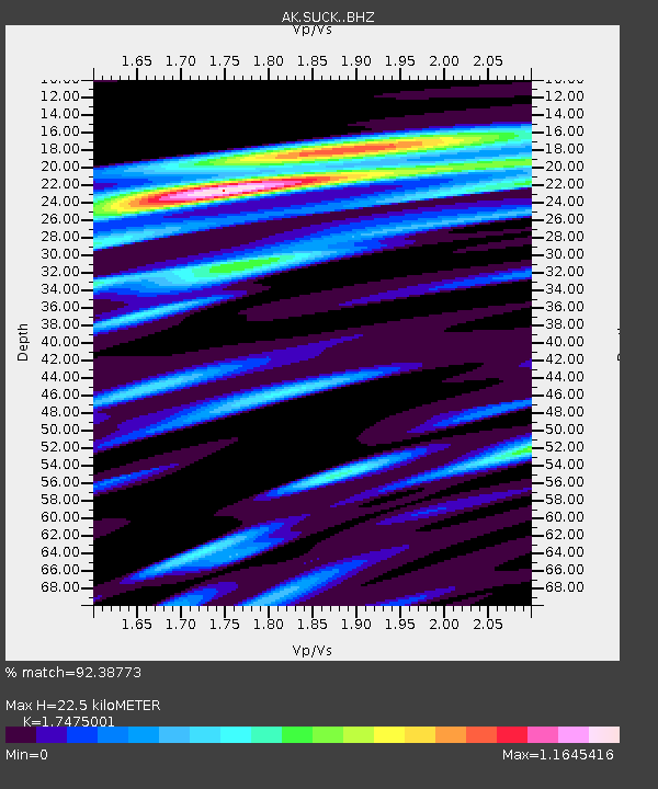
| Estimated Moho Depth: |
22.5 km |
| Estimated Crust Vp/Vs: |
1.75 |
| Assumed Crust Vp: |
6.566 km/s |
| Estimated Crust Vs: |
3.757 km/s |
| Estimated Crust Poisson's Ratio: |
0.26 |
|
| Radial Match: |
92.38773 % |
| Radial Bump: |
400 |
| Transverse Match: |
81.961075 % |
| Transverse Bump: |
400 |
| SOD ConfigId: |
11737051 |
| Insert Time: |
2019-04-25 04:54:03.730 +0000 |
| GWidth: |
2.5 |
| Max Bumps: |
400 |
| Tol: |
0.001 |
|

Signal To Noise
| Channel | StoN | STA | LTA |
| AK:SUCK: :BHZ:20160729T21:28:09.94801Z | 12.804943 | 9.3905355E-6 | 7.333524E-7 |
| AK:SUCK: :BHN:20160729T21:28:09.94801Z | 4.1316867 | 2.5074216E-6 | 6.0687603E-7 |
| AK:SUCK: :BHE:20160729T21:28:09.94801Z | 7.8401585 | 5.227054E-6 | 6.667026E-7 |
| Arrivals |
| Ps | 2.7 SECOND |
| PpPs | 9.0 SECOND |
| PsPs/PpSs | 12 SECOND |


