You are here: Home > Network List > CB - China National Seismic Network Stations List
> Station GTA Gaotai,Gansu Province > Earthquake Result Viewer
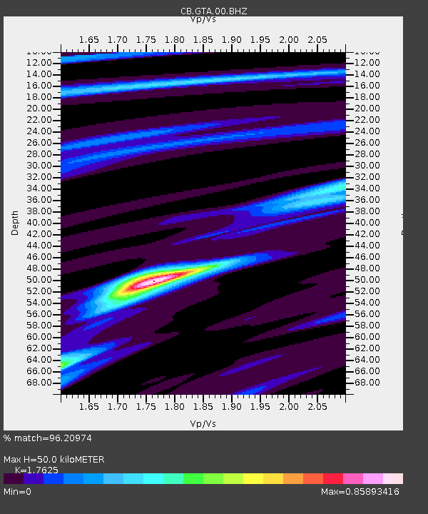
GTA Gaotai,Gansu Province - Earthquake Result Viewer
| Earthquake location: |
Mariana Islands |
| Earthquake latitude/longitude: |
18.5/145.5 |
| Earthquake time(UTC): |
2016/07/29 (211) 21:18:25 GMT |
| Earthquake Depth: |
212 km |
| Earthquake Magnitude: |
7.7 MWW, 7.7 MWB, 7.7 MI |
| Earthquake Catalog/Contributor: |
NEIC PDE/NEIC COMCAT |
|
| Network: |
CB China National Seismic Network |
| Station: |
GTA Gaotai,Gansu Province |
| Lat/Lon: |
39.40 N/99.82 E |
| Elevation: |
1345 m |
|
| Distance: |
44.5 deg |
| Az: |
307.726 deg |
| Baz: |
104.391 deg |
| Ray Param: |
0.07102557 |
| Estimated Moho Depth: |
50.0 km |
| Estimated Crust Vp/Vs: |
1.76 |
| Assumed Crust Vp: |
6.491 km/s |
| Estimated Crust Vs: |
3.683 km/s |
| Estimated Crust Poisson's Ratio: |
0.26 |
|
| Radial Match: |
96.20974 % |
| Radial Bump: |
177 |
| Transverse Match: |
59.78524 % |
| Transverse Bump: |
400 |
| SOD ConfigId: |
11737051 |
| Insert Time: |
2019-04-25 04:56:02.832 +0000 |
| GWidth: |
2.5 |
| Max Bumps: |
400 |
| Tol: |
0.001 |
|

Signal To Noise
| Channel | StoN | STA | LTA |
| CB:GTA:00:BHZ:20160729T21:25:46.81001Z | 53.4426 | 1.8070641E-5 | 3.3813177E-7 |
| CB:GTA:00:BHN:20160729T21:25:46.81001Z | 30.556267 | 2.2073232E-6 | 7.223798E-8 |
| CB:GTA:00:BHE:20160729T21:25:46.81001Z | 40.98453 | 1.02762915E-5 | 2.5073587E-7 |
| Arrivals |
| Ps | 6.3 SECOND |
| PpPs | 20 SECOND |
| PsPs/PpSs | 26 SECOND |


