You are here: Home > Network List > US - United States National Seismic Network Stations List
> Station BINY Binghamton, New York, USA > Earthquake Result Viewer
BINY Binghamton, New York, USA - Earthquake Result Viewer
| Earthquake location: |
Near Coast Of Chiapas, Mexico |
| Earthquake latitude/longitude: |
15.6/-93.1 |
| Earthquake time(UTC): |
2001/11/28 (332) 14:32:32 GMT |
| Earthquake Depth: |
85 km |
| Earthquake Magnitude: |
5.7 MB, 6.4 MW, 6.4 MW |
| Earthquake Catalog/Contributor: |
WHDF/NEIC |
|
| Network: |
US United States National Seismic Network |
| Station: |
BINY Binghamton, New York, USA |
| Lat/Lon: |
42.20 N/75.99 W |
| Elevation: |
498 m |
|
| Distance: |
30.4 deg |
| Az: |
25.648 deg |
| Baz: |
214.154 deg |
| Ray Param: |
0.07922043 |
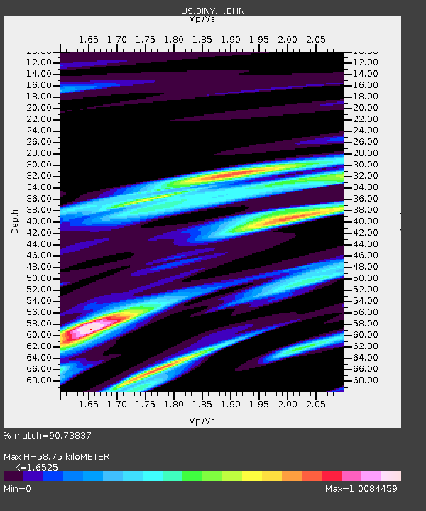
| Estimated Moho Depth: |
58.75 km |
| Estimated Crust Vp/Vs: |
1.65 |
| Assumed Crust Vp: |
6.419 km/s |
| Estimated Crust Vs: |
3.885 km/s |
| Estimated Crust Poisson's Ratio: |
0.21 |
|
| Radial Match: |
90.73837 % |
| Radial Bump: |
400 |
| Transverse Match: |
69.416016 % |
| Transverse Bump: |
400 |
| SOD ConfigId: |
20082 |
| Insert Time: |
2010-03-05 05:48:52.249 +0000 |
| GWidth: |
2.5 |
| Max Bumps: |
400 |
| Tol: |
0.001 |
|

Signal To Noise
| Channel | StoN | STA | LTA |
| US:BINY: :BHN:20011128T14:38:06.265013Z | 5.2301397 | 1.0753871E-6 | 2.0561345E-7 |
| US:BINY: :BHE:20011128T14:38:06.265013Z | 5.0332766 | 7.564129E-7 | 1.5028239E-7 |
| US:BINY: :BHZ:20011128T14:38:06.265013Z | 5.449321 | 1.8334396E-6 | 3.3645284E-7 |
| Arrivals |
| Ps | 6.5 SECOND |
| PpPs | 22 SECOND |
| PsPs/PpSs | 29 SECOND |


