You are here: Home > Network List > CI - Caltech Regional Seismic Network Stations List
> Station GLA Glamis, Glamis, CA, USA > Earthquake Result Viewer
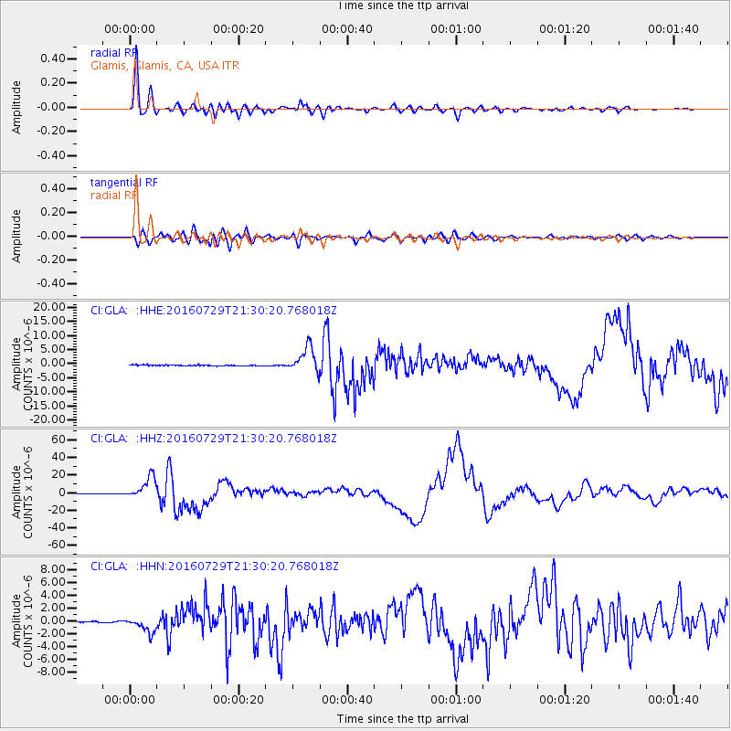
GLA Glamis, Glamis, CA, USA - Earthquake Result Viewer
*The percent match for this event was below the threshold and hence no stack was calculated.
| Earthquake location: |
Mariana Islands |
| Earthquake latitude/longitude: |
18.5/145.5 |
| Earthquake time(UTC): |
2016/07/29 (211) 21:18:25 GMT |
| Earthquake Depth: |
212 km |
| Earthquake Magnitude: |
7.7 MWW, 7.7 MWB, 7.7 MI |
| Earthquake Catalog/Contributor: |
NEIC PDE/NEIC COMCAT |
|
| Network: |
CI Caltech Regional Seismic Network |
| Station: |
GLA Glamis, Glamis, CA, USA |
| Lat/Lon: |
33.05 N/114.83 W |
| Elevation: |
610 m |
|
| Distance: |
87.8 deg |
| Az: |
55.953 deg |
| Baz: |
290.587 deg |
| Ray Param: |
$rayparam |
*The percent match for this event was below the threshold and hence was not used in the summary stack. |
|
| Radial Match: |
97.59328 % |
| Radial Bump: |
395 |
| Transverse Match: |
90.00835 % |
| Transverse Bump: |
400 |
| SOD ConfigId: |
11737051 |
| Insert Time: |
2019-04-25 04:56:29.763 +0000 |
| GWidth: |
2.5 |
| Max Bumps: |
400 |
| Tol: |
0.001 |
|
Signal To Noise
| Channel | StoN | STA | LTA |
| CI:GLA: :HHZ:20160729T21:30:20.768018Z | 59.703644 | 1.25571305E-5 | 2.1032436E-7 |
| CI:GLA: :HHN:20160729T21:30:20.768018Z | 13.07218 | 1.1641649E-6 | 8.9056684E-8 |
| CI:GLA: :HHE:20160729T21:30:20.768018Z | 26.7997 | 4.2901884E-6 | 1.6008346E-7 |
| Arrivals |
| Ps | |
| PpPs | |
| PsPs/PpSs | |


