You are here: Home > Network List > CI - Caltech Regional Seismic Network Stations List
> Station MPP McPhearson Peak > Earthquake Result Viewer
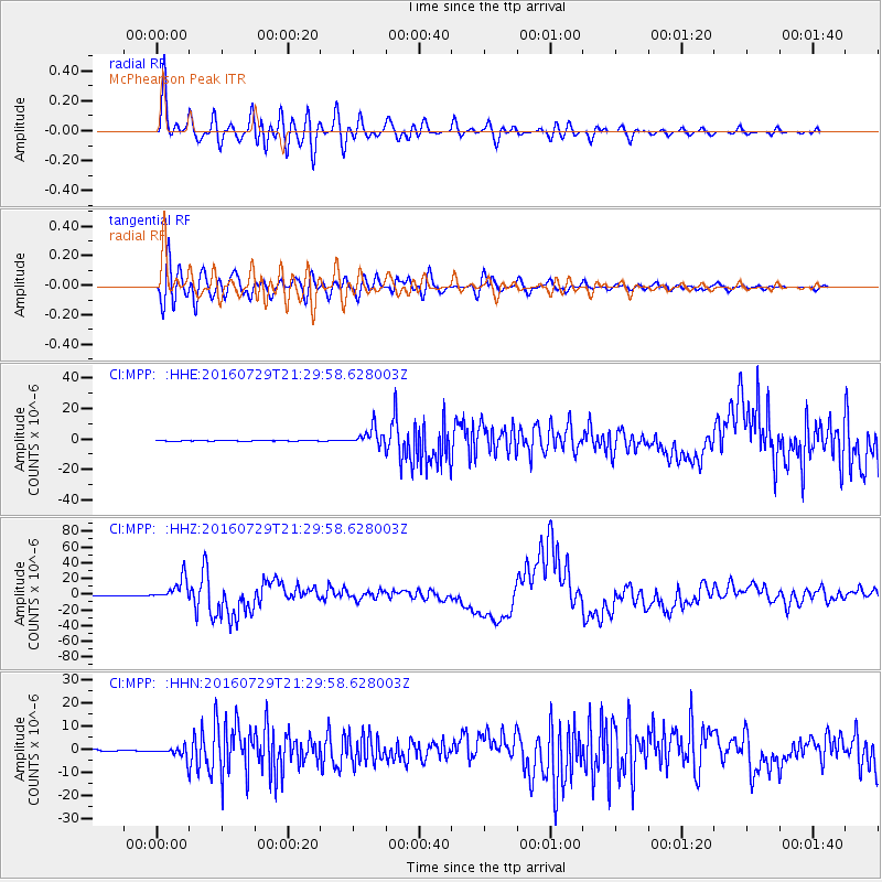
MPP McPhearson Peak - Earthquake Result Viewer
*The percent match for this event was below the threshold and hence no stack was calculated.
| Earthquake location: |
Mariana Islands |
| Earthquake latitude/longitude: |
18.5/145.5 |
| Earthquake time(UTC): |
2016/07/29 (211) 21:18:25 GMT |
| Earthquake Depth: |
212 km |
| Earthquake Magnitude: |
7.7 MWW, 7.7 MWB, 7.7 MI |
| Earthquake Catalog/Contributor: |
NEIC PDE/NEIC COMCAT |
|
| Network: |
CI Caltech Regional Seismic Network |
| Station: |
MPP McPhearson Peak |
| Lat/Lon: |
34.89 N/119.81 W |
| Elevation: |
1739 m |
|
| Distance: |
83.3 deg |
| Az: |
55.584 deg |
| Baz: |
287.784 deg |
| Ray Param: |
$rayparam |
*The percent match for this event was below the threshold and hence was not used in the summary stack. |
|
| Radial Match: |
94.67583 % |
| Radial Bump: |
400 |
| Transverse Match: |
89.36816 % |
| Transverse Bump: |
400 |
| SOD ConfigId: |
11737051 |
| Insert Time: |
2019-04-25 04:56:44.057 +0000 |
| GWidth: |
2.5 |
| Max Bumps: |
400 |
| Tol: |
0.001 |
|
Signal To Noise
| Channel | StoN | STA | LTA |
| CI:MPP: :HHZ:20160729T21:29:58.628003Z | 46.835735 | 1.4174544E-5 | 3.026438E-7 |
| CI:MPP: :HHN:20160729T21:29:58.628003Z | 5.2057643 | 1.9403547E-6 | 3.7273193E-7 |
| CI:MPP: :HHE:20160729T21:29:58.628003Z | 22.599771 | 5.5033897E-6 | 2.4351527E-7 |
| Arrivals |
| Ps | |
| PpPs | |
| PsPs/PpSs | |


