You are here: Home > Network List > US - United States National Seismic Network Stations List
> Station BINY Binghamton, New York, USA > Earthquake Result Viewer
BINY Binghamton, New York, USA - Earthquake Result Viewer
| Earthquake location: |
Southern Alaska |
| Earthquake latitude/longitude: |
59.0/-155.1 |
| Earthquake time(UTC): |
2001/07/28 (209) 07:32:43 GMT |
| Earthquake Depth: |
131 km |
| Earthquake Magnitude: |
5.7 MB, 5.7 MS, 6.6 MW, 6.2 ME |
| Earthquake Catalog/Contributor: |
WHDF/NEIC |
|
| Network: |
US United States National Seismic Network |
| Station: |
BINY Binghamton, New York, USA |
| Lat/Lon: |
42.20 N/75.99 W |
| Elevation: |
498 m |
|
| Distance: |
49.8 deg |
| Az: |
72.777 deg |
| Baz: |
318.329 deg |
| Ray Param: |
0.068011254 |
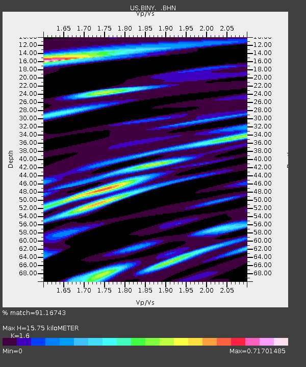
| Estimated Moho Depth: |
15.75 km |
| Estimated Crust Vp/Vs: |
1.60 |
| Assumed Crust Vp: |
6.419 km/s |
| Estimated Crust Vs: |
4.012 km/s |
| Estimated Crust Poisson's Ratio: |
0.18 |
|
| Radial Match: |
91.16743 % |
| Radial Bump: |
400 |
| Transverse Match: |
81.92281 % |
| Transverse Bump: |
400 |
| SOD ConfigId: |
110165 |
| Insert Time: |
2010-03-05 05:48:59.214 +0000 |
| GWidth: |
2.5 |
| Max Bumps: |
400 |
| Tol: |
0.001 |
|
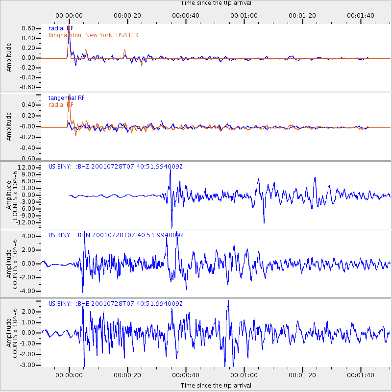
Signal To Noise
| Channel | StoN | STA | LTA |
| US:BINY: :BHN:20010728T07:40:51.994009Z | 4.1531434 | 9.766283E-7 | 2.3515399E-7 |
| US:BINY: :BHE:20010728T07:40:51.994009Z | 3.2497084 | 6.672887E-7 | 2.0533803E-7 |
| US:BINY: :BHZ:20010728T07:40:51.994009Z | 8.176024 | 2.8986253E-6 | 3.5452751E-7 |
| Arrivals |
| Ps | 1.6 SECOND |
| PpPs | 6.0 SECOND |
| PsPs/PpSs | 7.6 SECOND |


